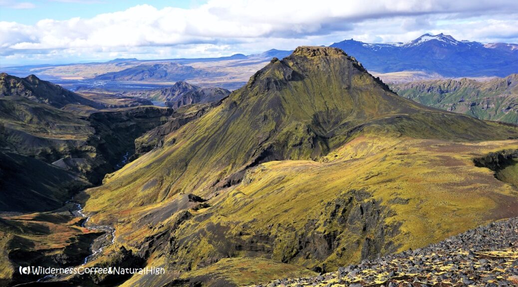
Thórsmörk – Útigönguhöfði and Hvannárgil canyon
Thórsmörk is full of folded valleys and convoluted canyons, glaciers with volcanoes underneath, and bizarrely shaped mountains with unpronounceable names. The most prominent is Útigönguhöfði – the ridiculously steep mountain you see looming everywhere in Thórsmörk. The impressive Hvannárgil canyon runs below its slopes and together they form a beautiful circuit, with jaw-dropping views from one end to the other.
The queen of Thórsmörk
Útigönguhöfði is the queen of Thórsmörk. It stands majestically tall & proud, embraced by the mighty valleys of the Krossá and Hvanná rivers. You just can’t help standing in awe & admiration before it. And climbing it is as challenging as pronouncing its name… 😉
In this article you can read about hiking the Útigönguhöfði and Hvannárgil circuit. Be prepared for some serious crawling up the rocks on either side!

Hvannárgil canyon upper path.
How to climb Útigönguhöfði
Útigönguhöfði was the unexpected grand encore on my way back from Fimmvörðuháls in September 2017. It looked like a shorter route on the map, but that turned out to be slightly different…
So I decided to climb it again in the right way when I came back to Thórsmörk a year later. This time I made sure I had plenty of margin to enjoy the views.

Angelica plant with Útigönguhöfði looming in the background.
Best hiking route to Útigönguhöfði
The ‘easiest’ way up to Útigönguhöfði is via the path from the Básar hut on the west side of the mountain. I wouldn’t recommend going over Útigönguhöfði on the way down from Fimmvörðuháls. It’s easy to lose track from that direction, and there are only a few marker poles to indicate the route beyond the Morinsheiði plateau.
The Útigönguhöfði hike requires some serious crawling on either side. But at least on the Básar side you can still see where the track is going, and there are chains attached to the upper parts. The views from the top are absolutely worth the hardcore slogging up the mountain!
How much time do you need?
From the Básar hut it takes about 2 hours to walk to the top of Útigönguhöfði, at a lofty height of 800 metres. Count on at least 7 to 8 hours for the entire circuit with Hvánnargil Canyon, including rest breaks for a picnic and a Wilderness Coffee. And of course enough time to take in the incredible scenery.

Epic view from the top of Útigönguhöfði.
Lower Fimmvörðuháls route
You can also combine either Útigönguhöfði or Hvannárgil with the lower section of the Fimmvörðuháls route, the Thórsmörk volcano hike up to Eyjafjallajökull. The Fimmvörðuháls path is more established and easier to follow. This part of the route includes the famous ‘Cat Ridge’ (Kattarhryggir, or cat’s spine).
All of these hiking routes come together on the Morinsheiði plateau above the Thórsmörk valley. If you want to do a circuit with the lower Fimmvörðuháls path, the best combination is:
- Go up to Útigönguhöfði first and back down via Fimmvörðuháls.
- Take the Fimmvörðuháls path first and go back down via Hvannárgil canyon.

Kattarhryggir, the famous Cat Ridge in the Fimmvörðuháls route.

The giant Morinsheiði plateau.
Steep mountains and deep canyons
Like the Laugavegur, the Fimmvörðuháls route is very popular and it can get pretty crowded on the track in the summer. The Útigönguhöfði route is less well-known, and perhaps slightly discouraging due to its intimidating steepness…
There are several steep sections on Fimmvörðuháls too, but nowhere near as the ones on Útigönguhöfði – especially on the way down towards Morinsheiði.

Útigönguhöfði upper path. Yes, it’s steep…
Útigönguhöfði and Hvannárgil canyon circuit
The hiking route to the top of Útigönguhöfði starts right behind the Básar hut. The path follows the ridge above the huts to the Votupallar plateau, before it leads up the steep & craggy slope of Útigönguhöfði itself. Vottupallar is also the point where you emerge from the Hvannárgil canyon on the way back.
On the signposts near Básar you’ll see two different paths to Útigönguhöfði, but eventually they both lead to Votupallar. The lookout point on the edge of the plateau offers amazing views into the Hvannárgil canyon – see the photo further down in this article!

Signposts to the Útigönguhöfði hiking route near the Básar hut.

The path up to Útigönguhöfði.

Looking down and across towards Réttarfell.
Panoramic views over Thórsmörk
The top of Útigönguhöfði is a surprisingly flat plateau, covered with mossy areas and decorated with bizarrely shaped rocks & boulders sticking out on the sides.
And it offers some of the best views over the entire valley of Thórsmörk.

View from the top into the valley of Thórsmörk.

View towards Katla and Mýrdalsjökull glacier.

Bizarre rock pillars and more epic views.
Picnic with a view on the top!
I spent at least an hour bumbling around, enjoying the stunning surroundings and a picnick on the top. There’s nothing quite like a Wilderness Coffee with a view… 😉
And like the last time, I was lucky again that there was hardly any wind. Going up to Útigönguhöfði when the notorious Icelandic winds are howling around the flanks is just not a good idea.

Picnic & Wilderness Coffee with a view from the top of Útigönguhöfði.

The rollercoaster view down the slope of Útigönguhöfði…
Daunting descent to Morinsheiði
On the other side of the Útigönguhöfði top awaits the descent down that dauntingly steep gravel slope… It’s like a rollercoaster view when you’re standing at the edge of it! This is where you have to be extremely careful, even crawl down on your bum and hands and feet if necessary. It may not look very elegant, but it’s the most practical and safest way if you don’t want to break an ankle (or worse…)
Hiking sticks can be a benefit, if you’re comfortable with them.
Sliding rollercoaster slope
The gravelly bits are one of the most tricky & treacherous things to navigate as you’re going down. No matter how good or sturdy your hiking boots are, the gravel will slide from underneath you.

The bone-thin marker sticks on this side can be difficult to spot…

Path down the back side of Útigönguhöfði.
Morinsheiði plateau
The same thing goes for the descent into the upper part of the Hvannárgil canyon from Morinsheiði. That’s the only ‘downside’ of this route: you have to slide & shuffle down extremely steep slopes full of loose bits of gravel twice…!

Signpost on Morinsheiði above Hvannárgil canyon.
The gateway to Eyjafjallajökull
Up on Morinsheiði the path joins the main Fimmvörðuháls route in the middle of the plateau. Turn right and follow the track until you get to the signpost just before that beautiful ridge leading to the upper reaches of Fimmvörðuháls, the gateway to Eyjafjallajökull.
The king of Thórsmörk
If Útigönguhöfði is the queen of Thórsmörk, Eyjafjallajökull is the king. The one that rules them all. He showed off his power in 2010.

Heljarkambur, the ridge on Morinsheiði.
Heljarkambur – Hell’s Ridge
The name of the ridge doesn’t do it justice. It’s called Heljarkambur, meaning ‘Hell’s Ridge’. But the surroundings and views are awe-inspiring. To the left of it lies Hrunagil canyon, stretching out to the east of Morinsheiði.
Hrunagil canyon is where spectacular lava falls more than 200 metres long (!) 😳 drooped down from Eyjafjallajökull during the 2010 eruption at the Fimmvörðuháls fissure. Surpassing the Glymur waterfall in height, this effectively made it the tallest liquid ‘waterfall’ in Iceland at the time.

Heljarkambur ridge and Hrunagil canyon.

Sliding down gravelly slopes into Hvannárgil canyon…
Hiking route into Hvannárgil canyon
To the right of Heljarkambur ridge the track descends into the convoluted canyon of Hvannárgil – and down more gravelly slopes again. Especially this first section is quite rough at the start.
You’ll pass beneath giant boulders clinging to the slopes above, troll faces watching over the canyon, and cross little glacial streams fed by waterfalls.

Troll face watching over Hvannárgil canyon.

Giant boulders & glacial streams.

Canyon path looking back towards Fimmvörðuháls.
Meandering beneath the slopes of Útigönguhöfði
After a while the track becomes more level as it circles along the upper slopes of the canyon. The worst of the sliding gravel sections are behind you now!
The path drops down to the river where it flows beneath the slopes of Útigönguhöfði. Then it climbs up to the canyon ridge again, eventually emerging at the Votupallar viewpoint.

Hvannárgil canyon path below Útigönguhöfði.

The canyon floor, covered with blueberry plants.

Glacial streams flowing through a rocky gateway.

Going up the canyon ridge again.
Stunning views into the Hvannárgil canyon
The walk inside the canyon from Heljarkambur ridge on Morinsheiði to Votupallar takes about 2 hours, with incredible views from one end to the other.
Votupallar is the plateau in front of Útigönguhöfði on the west side of the mountain. When you walk towards the edge of it, you can see this stunning view into the lower Hvannárgil canyon.

View into the lower Hvannárgil canyon.
Wonky knees
From Votupallar it’s another hour’s walk back to the Básar hut. My legs & knees felt quite wonky at the end of the day, after navigating all those sliding gravel slopes! But thankfully they sprang back into shape again after a good night’s sleep.
And I was ready to conquer that other steep mountain in Thórsmörk – Rjúpnafell.

The Básar hut and Krossá river.

Fjallalæðas forming on the ridges, with Mount Rjúpnafell sticking out to the left.
(*) Fjallalæða – the mountain equivalent of a dalalæða. 😉
Útigönguhöfði & Hvannárgil hike summary
Distance: 11 kilometres circuit from the Básar hut.
Time: About 7 to 8 hours.
Altitude: 260 metres above sea level at the start & finish.
Útigönguhöfði summit: 800 metres above sea level.
Highest points: Útigönguhöfði and Heljarkambur ridge (both around 800 metres).
Difficulty: Very challenging. Extremely steep & gravelly sections up and down.
Útigönguhöfði & Hvannárgil map
This handy interactive map shows the hiking route I took from Básar up to Útigönguhöfði and Morinsheiði, and back down via the Hvannárgil canyon. Zoom in on the different sections of the track for more details. You can also click on the icons to see the stunning views along the way.
@ This is one of the top-5 reader’s favourites of 2019, 2020 and 2022.

My (well-used!) map of hiking routes in Thórsmörk.
Thórsmörk hiking routes
The Thórsmörk hiking map above shows the Útigönguhöfði and Hvannárgil circuit as the long red loop south of the Krossá river valley. You can find these maps outside at the Básar hut and other huts around Thórsmörk. The hut wardens also sell detailed maps with all the hiking routes.
@ See this article for practical tips & information about Thórsmörk, how to get there and where to stay.

Útigönguhöfði – the alternative route
For a complete surround view I also added the story about my first encounter with Útigönguhöfði. This was on my way down from Fimmvörðuháls in September 2017. And definitely more tricky to climb it from that direction…!
I thought it might be interesting to take a different route on the way back. Someone at the hut had mentioned another track leading back down from the Morinsheiði plateau, towards Útigönguhöfði, with even more spectacular views on the way. It was also marked on the map I bought. It looked like a shorter route, so I figured I had plenty of margin left.
That turned out to be a little different from what I expected…
Lack of signposts
Halfway across Morinsheiði there was a signpost pointing to the Útigönguhöfði route. The track went down the side of the plateau and into broad mossy meadows. There were marker poles to indicate the route, but they became progressively fewer and far between as I walked further towards the humongous big mountain rising up in front of me.

Lost on Útigönguhöfði mountain
I expected that the track would weave around the mountain and back down the valley on the other side. It couldn’t possibly be going over it. The steepness was just too intimidating, and it looked nearly impossible to actually go over there.
At some point, I lost track of the poles and couldn’t see the next one. I wandered around for a bit towards the side of the valley, hoping to see a reassuring pole to confirm that I’m going in the right direction. It was nearly 6 o’clock, less than 2 hours before sunset, and I was still way out in the wilderness. There wasn’t a pole to be seen anywhere. So I walked back up the hill again to find the previous pole, and carefully scanned the surroundings for the next.
Then I finally spotted it. It was halfway up the Útigönguhöfði mountain.

Can you see the marker pole on Útigönguhöfði…?!
Nooo! You have got to be kidding me!
A slight panic was starting to take hold.
It was too late to go back up the Morinsheiði plateau again and continue on the conventional route. It would still take another 3 hours to go that way. There was no other choice than to crawl my way up this humongous big & frightfully steep mountain, hoping to make it back down the other side before it got completely dark. Luckily there’s a long twilight zone in Iceland. After the sun has set, darkness moves in slowly, and there will be at least another hour before it gets completely dark.
My battery is low and it is getting dark
I checked my phone and saw that I only had 4% of battery left. That might be a bit of a problem if I had to call 112 in case of getting stuck on the mountain in total darkness…

View back down from the top of Útigönguhöfði, its terrifying shadow looming over the valley.
Terrifying & terrific views
So I crawled up the Útigönguhöfði mountain like an animal, while the sunlight was already leaving the valley behind me at an alarming rate. And I made it to the top just in time to see a breathtakingly magical sunset on the other side, lighting up a mind-boggling array of gorges in translucent shades.
From here, the track became easier to follow. At least there were chains & ropes on the way down, and you can actually see where the path was going on this side. There was even a rickety weather-beaten signpost on the top!
Back just in time
I got back to the Básar hut just before it really got too dark – after nearly 12 hours of walking up and down two great big mountains. It might not have been the most logical decision to choose an obscure track two hours before sunset… But it was worth it in the end!
Magical sunset over Thórsmörk.

What is the best Útigönguhöfði circuit?
It can be a bit difficult to choose what loop to do from Útitgönguhöfði… Going back via Hvannárgil canyon or the lower Fimmvörðuháls route? They are both stunning!
The Fimmvörðuháls track is definitely more established and easier to follow than the canyon path. Especially the far end of Hvannárgil is quite rough at the start, when you are sliding down into the canyon from Heljarkambur ridge. There are also less people hiking in Hvannárgil canyon than on the Fimmvörðuháls route.
Ultimately it all depends on your personal situation and feelings. See how it goes after you’ve gone over Útitgönguhöfði and what you feel like once you get up to Morinsheiði. And decide at the crossroad which path you will take on the way down, depending on the weather and the time of day. You can peek into Hvannárgil canyon (or do a little side-track into it) from the Votupallar lookout point just before you go up to Útigönguhöfði. This way you can still see a bit of the canyon if you take the Fimmvörðuháls track.
Útigönguhöfði loops from Básar
These are the different options for the Útigönguhöfði hike:
- Go up to Útigönguhöfði and back down through the upper Hvannárgil canyon. This is the entire circuit via Morinsheiði and Heljarkambur.
- Go up to Útigönguhöfði and back down via Fimmvörðuháls from Morinsheiði.
- Go up to Útigönguhöfði and back down the same way. Further on there’s also a different path back to the Básar hut.
- Go up to Útigönguhöfði and back down the same way. From Votupallar you can then continue into the lower part of Hvannárgil canyon until you see a path back to the Básar hut near Réttarfell.

@ If you have any questions, let me know in the comment section below. I’d love to hear from you! Your questions, comments and suggestions are also helpful for other readers and travellers. Thank you for sharing.
Follow Wilderness Coffee & Natural High on Facebook and Instagram for more stories.

The queen of Thórsmörk (in the background. 😉 )
More to explore & discover
Kerlingarfjöll – Steaming valleys and surreal landscapes
The zen of Stafsnes – The hidden beach
Mount Titlis – Alpine meadows & mountain views
El Hierro – A volcanic hotspot underneath the sea
Vierdaagse of Nijmegen – Four days of long-distance trials & tribulations
© All photos and content on this website are my own, and subject to copyright (unless credited otherwise). Please contact me if you want to use a photo or quote a text from one of my articles. You’re welcome to share a link to my blog articles and photos on social media, with a tag and mention to Wilderness Coffee & Natural High.
The fabled valley of Thórsmörk
The fantastic surround views from the top of Útigönguhöfði.
This article was first published on 18 November 2018.
6 thoughts on “Thórsmörk – Útigönguhöfði and Hvannárgil canyon”
I have read tons of articles about Iceland (and visited 3 times!), but none are as great as your posts. Yours are truly fantastic. Thank you! I’d like to ask you a question. We will spend 2 full days in Thorsmork in August (staying overnight) and we are avid hikers. Assuming good weather. Which two hikes would you suggest? I was thinking 1- Rjupnafell, and not sure if to do 2- either the up on Útigönguhöfði and down on Fimmvörðuháls or down through the canyon trail. Any suggestions are greatly appreciated – even suggesting a totally different route. Thank you.
Hello Veronica, thank you so much for your compliment, I really appreciate it. 🙂 Yes, it can be a bit difficult to choose what loop to do from Útitgönguhöfði… they are both stunning! I have also added this information in the article to make it easier for people to decide:
The Fimmvörðuháls path is more established and easier to follow than the canyon path. Especially the far end of Hvannárgil, when you are sliding down into the canyon from Heljarkambur ridge, is quite rough in the beginning. There are also less people hiking in Hvannárgil canyon than on the Fimmvörðuháls track. I would say, see how it goes after you’ve gone over Útitgönguhöfði and what you feel like once you get up to Morinsheiði. And decide at the crossroad which path you will take on the way down, depending on the weather and the time of day. Alternatively, you can peek into the canyon, or do a side-track into it, from the Votupallar lookout point just before you go up to Útigönguhöfði. This way you can still see a bit of the canyon if you decide to take the Fimmvörðuháls track.
Did you see my article about the new Fagradalsfjall volcano on Reykjanes peninsula? It’s not erupting at the moment, but could still go off again at any time. But even if it stays quiet, the area around it with its extensive lava fields is an incredible sight to see. It’s about 40 minutes drive from the airport and you can find extensive information & tips in the article.
I’d love to know what path you decide to do when you get there!
If you have any questions, please post them directly in the comment box below.
—
I received this comment & question by email from Greg (USA):
‘Thank you so much for all the information you have shared. It is amazing what you have done and I hope to follow in your footsteps. Would you have a picture of the trail map to Thórsmörk. I am looking to do the same hike as you from Basar to Útigönguhöfði and see the Hvannárgil canyon, but I do not want to do the entire circuit. I am looking for a way to see the canyon from above and then turning around and returning to Basar. Would you be able to provide any more information because I can not find any trail maps. Thank you for all that you do.’
Here’s my reply – so others with similar questions can read this too: @ ‘Hello Greg, thanks for your message! I have added a picture of the hiking routes around Útigönguhöfði to the blog article because of your question. You will see these type of maps on information boards at the huts in Thórsmörk. They also sell detailed maps with all the hiking routes, which are very useful if you’re planning to do more walks.
You don’t need to do the entire circuit to see the Hvannárgil canyon from above (as on the picture in my article). Just follow the signposts from the Básar hut towards Útigönguhöfði until you reach a point called Votupallar. That’s where you will have those amazing views. There’s also another marked track from Básar to the lower end of Hvannárgil canyon.
Have a great time in Iceland and Thórsmörk!’
P.S.: If you plan to see the volcano that’s erupting in Reykjanes at the moment, check out my recent article about Fagradalsfjall for practical information, maps, videos, and of course lots of pictures.
I received these questions by email from Irmgard (Germany):
‘Dear Nancy, I happened to find your report Thórsmörk – Útigönguhöfði and Hvannárgil Canyon and absolutely loved it. However, I think our family (with two adult sons) is not quite as sportsy as you are. My questions: Where can we find this stunning view into the lower Hvannárgil canyon? What is the best way to see this view if we are not prepared for some serious crawling up the rocks or make it up (or down) Útigönguhöfði? We have booked the bus to arrive in Basar at 11:15 and we can leave from Volcano Huts Husadalur at 18:00 or from Basar at 18:30. We have around 6 to 6,5 hours for the hike. Any comments and suggestions would be greatly appreciated. Thank you so very much in advance! Kind regards, Irmgard.‘
These are my suggestions – so other families with similar questions can read this too: @ ‘Hi Irmgard, thank you for your lovely mail and for reaching out. I’m glad you enjoyed my blog post about Útigönguhöfði . And yes, those views into the Hvannárgil canyon are indeed stunning…
The view on the picture is on the side of the canyon, near a lookout point called Votupallar. This is the plateau in front of Útigönguhöfði. You don’t need to scramble up the mountain itself to see it. The best way to reach it is to take the path from Básar huts, and follow the direction of Útigönguhöfði. Both paths to Útigönguhöfði are leading to Votupallar. From there, you take the path to the right, towards the canyon. It’s easy to see, because the other path goes right up towards Útigönguhöfði.
If you have 6,5 hours to spend in Thórsmörk you will have enough time to do this walk and return to Básar huts. It takes roughly another hour to walk from Básar to Volcano Huts across the bridge over the Krossá river. I would only do that if you have enough time left to catch the bus from there. Otherwise I’d recommend to take it from Básar, so you have more time to spend in this area. It’s very easy to get distracted by all those views! Thórsmörk is such a beautiful place, it’s worth spending a few nights there if you have the chance.
Be sure to leave a comment on the blog when you have done the walk. I’d love to know how you liked it.’
I have also updated the article with additional information based on Irmgard’s questions.