Kerlingarfjöll – Steaming valleys and surreal landscapes
The hot spring valley of Hveradalir in the Kerlingarfjöll mountains is something out of this world. Breathtaking views unfold into a steaming geothermal valley padded with snowfields clinging to the slopes, and shapes and colours so magnificient that you wonder if it’s even real. It’s like you’ve stepped into a surrealistic painting.
The bad weather mountains
Located along the Kjölur road in the remote interior of Iceland, Kerlingarfjöll was once considered a hiding place where only trolls and outlaws would venture.
For centuries, the Kerlingarfjöll mountain range was known as the Bad Weather Mountains. And that’s exactly what they looked like when I arrived. At the end of June, the start of summer, it was still a mere 2 degrees. There had been a snowstorm the night before, and low-hanging clouds gloomily covered the horizon. I was greeted by some nasty gusts of wind and icy rain, and wondered what on earth I was doing here…

Hveradalir valley ridges.

Kerlingarfjöll hot spring valley
This all doesn’t sound very inviting, but don’t be discouraged! Kerlingarfjöll and the hot springs in the Icelandic highlands are absolutely worth a visit. You won’t regret a trip into the otherworldly steaming valley of Hveradalir, no matter what the weather conditions are. Besides warm, wind- & rainproof clothes, another essential item to take to Kerlingarfjöll is a swimsuit. 😉
And fortunately the weather was about to improve – if only slightly – to reveal the true beauty of this incredible geothermal landscape.

Surreal landscapes and steaming rivers in Hveradalir.

Various volcanic and geological features
Kerlingarfjöll is nestled beneath the shadow of Hofsjökull glacier. It sits at the intersection where the Eastern and Western Volcanic Riftzones merge before they continue north as one.
This creates a mad combination of terrain, with geothermal activity colliding in spectacular displays with packs of snow and ice and glaciers. A huge massif of colourful rhyolite mountains, intersected by steaming gullies and valleys, where the earth is fuming, hissing, bubbling and gurgling from several nooks and crannies. The whole mountain range is basicly one big caldera, created by eruptions from underneath at a time when there were still glaciers on top of it.
It’s like Landmannalaugar on steroids!

Thick packs of ice dropping down into hot streams.

Bizarre rock formations and steaming fumaroles.
Where to stay in Kerlingarfjöll
There is a variety of places to stay at the Kerlingarfjöll Highland Base. The mountain hut and cabins have been thorougly renovated and extended with fancy hotel room options. The new resort opened in July 2023.
The resort and cabins are nestled in the Ásgarður valley beside the F-347 mountain road, about 10 kilometres from the main F-35 Kjölur road. Once you’ve made it this far into the wilderness, plan to stay at least 2 or 3 nights. You’ll want to have enough time to explore the scenery (and some margin in case of really bad weather…)

The old Kerlingarfjöll mountain hut & cabins before the renovation.
Ásgarðsá river gorge and hot pool
From the Highland Base a path beside the river leads into a progressively spectacular gorge to a welcoming hot pool. It takes about 30 minutes to get there. Unfortunately the hot pool area lacks a proper shelter to keep your clothes dry in case of rain & drizzle.
But a plastic bag or backpack cover will do the trick.

The hot pool and Ásgarðsá river near Kerlingarfjöll Highland Base.
The blissful hot pool of Kerlingarfjöll
In spite of the not-so-inviting weather on the day I arrived, I wanted to make the most of it and wandered off towards the hot pool river. Once you’re in the pool, you drift away in pure bliss. You’re warmed up from the inside out, like the geothermal valley itself.
The hardest part is getting out of it again! But by then you’ve regenerated enough warmth to brave the slippery (and sometimes snowfield-covered) path back to the cabins.

Ásgarðsá river gorge.
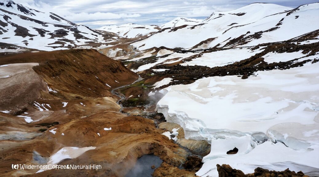
Hveradalir geothermal valley
The major attraction in Kerlingarfjöll is the Hveradalir geothermal valley. This amazing valley of hot springs is about 5 kilometres from the cabins. It’s one of the largest geothermal hot spring areas in Iceland, and it really is spectacularly beautiful.
Geologists and photographers will have a field day here! 😀

Kerlingarfjöll hot spring valley and steaming rivers.

The Hveradalir track goes over the hills towards the snowy pass between the two mountains in the background…
Kerlingarfjöll hike to Hveradalir
The walking track to Hveradalir starts right across from the Ásgarðsá river, at the bottom of the hill behind the Kerlingarfjöll campsite. You can do a circuit and return via the jeep road (F-347) from the Neðri-Hveradalir parking area above the other side of the valley. Inside Hveradalir there’s a 4-kilometre loop with several side tracks.
How much time do you need?
You will need at least 5 to 6 hours to hike to Hveradalir and back, have enough time to bumble around in the valley, and a much needed picnic lunch & Wilderness Coffee along the way. And to take photos – you just can’t help it. The valley is extremely photogenic. There are beautiful compositions everywhere you look. You can easily spend hours in this fascinating area.

View into Hveradalir from the carpark.
Valley loop from the Neðri-Hveradalir carpark
If you have a (4WD) car, you can also drive up the hill behind the Kerlingarfjöll Highland Base to the Neðri-Hveradalir parking area on the F-347 road. From there it’s a short walk into the geothermal valley itself.
But then you will miss the spectacular sights along the hiking track from the campsite!

Hveradalir valley hiking routes.
Hiking route from Kerlingarfjöll Highland Base
As you walk up the hill behind the campsite, spectacular views into the gorgeous Ásgarðsgljúfur gorge unfold on the left, and towards the snow-covered mountains Hveradalahnúkur and Mænir looming in front. Even more peaks peek out behind them, if they’re not hiding in the clouds.
It takes about 1,5 hours of uphill ploughing over windy ridges and across exposed stonefields to reach the Hveradalir valley. Depending on the time of year, there are several snowfields of varying depth and intensity to cross.

Snowfields and the mountain pass on the way to Hveradalir.

Fuming fumaroles
The hiking track winds between the mountains Hveradalahnúkur and Hveradalaklif, and across another stony plateau to the right. As you walk toward Mænir, you are suddenly greeted by the invigorating smell of sulphur wafting from the distance.
This is coming from the Snorrahver fumarole, furiously steaming from a ridge above the geothermal valley.

Snorrahver fumarole.

Signposts on the stony plateau.
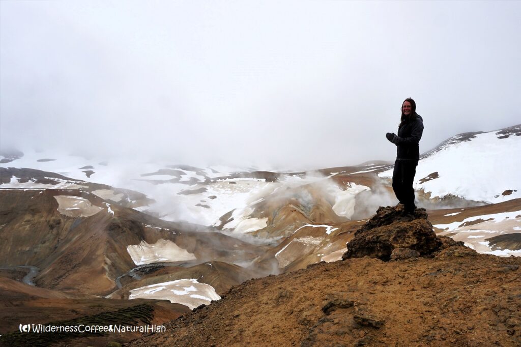
Surreal panoramic views
It can be painfully windy at this point. But when you look down into the gorge below, it makes you instantly forget the uncomfortable gusts of wind around your head. You can only stand in awe and admit that it is indeed exceptionally beautiful.
Breathtaking views unfold into a steaming valley padded with snowfields clinging to the slopes, and shapes and colours so magnificient that you wonder if it’s even real. It’s like you’ve stepped into a surrealistic painting.

The surreal view into Hveradalir valley from the top of the plateau.
Hot springs and geothermal terraces
Thick packs of ice are dropping down from the surrounding mountains and melted into bizarre shapes by the geothermal heat below. Hot and cold streams circle around a multitude of ridges, with angry jets of steam spouting from various cracks.
At the bottom of the valley there are vigorously boiling hot springs and bubbling mudpools. Even pretty mini-terraces have formed in a quiet corner in one of the streams.

Various bubbling hot springs.

Cute mini-terraces.

Steaming fumarole jets.
Paths up muddy ridges
By the time you reach the valley, your shoes will have increased twice their size and weight, due to the sticky geothermal mud that is nearly impossible to avoid along the track.
The river and streams are crossed by small walking bridges. Several paths are going up the muddy ridges in different directions, accumulating even more mud on your shoes…
There’s a little picnic spot tucked away in a pretty corner by the river – a perfect place to enjoy a Wilderness Coffee surrounded by steaming ridges and streams!

The muddy ridges of Hveradalir valley.

Surreal steaming mountainsides.

Picnic place by the river.

Mount Mænir looming high above Hveradalir valley.
Hveradalir hike summary
Distance: 14 kilometres return from the Kerlingarfjöll Highland Base.
Time: About 5 to 6 hours.
Altitude: 700 metres above sea level at the start & finish.
Highest point: Hveradalahnjúkur plateau near Snorrahver at 1080 metres.
Difficulty: Challenging. Snowfields and muddy ridges that can be very slippery.
Kerlingarfjöll map
This handy interactive map shows the hiking route I took from the Highland Base to Hveradalir valley, and back via the Neðri-Hveradalir F-347 mountain road. You can also zoom in for more details, and click on the icons to reveal pictures of stunning views.
Weather and hiking conditions
If you consider going on a hike in Kerlingarfjöll, always check the weather and track conditions before you set off. You don’t want to find yourself blown off the mountain and disappearing into some bottomless snowfield down the slope. August is generally the best option, as there can still be a lot of snow at the end of June or early July!
You can find up-to-date conditions on Safe Travel Iceland and Umferðin (the Icelandic Road Administration), and their various social media outlets.

This is what your shoes look like after a walk around Hveradalir!

Walls of snow along the road back down from Neðri-Hveradalir, with a great view into the Ásgarðsgljúfur canyon.
How to get to Kerlingarfjöll
The F-35 Kjölur road and the F-347 turn-off to Kerlingarfjöll are only accessible during the summer months by sturdy 4WD vehicles. You will need to cross a few rivers, including one above a waterfall. Accessibility is subject to when the road is declared open by Umferðin.
Unfortunately the Kjölur bus service between Reykjavík and Akureyri was cancelled in 2020, and hasn’t been reactivated yet. The only option to go there is by private transfer, or by renting a 4WD car.
Renting a car for the Icelandic highlands
If the road conditions are good, a mid-sized SUV (4WD) such as a Dacia Duster, Jeep Renegade, Suzuki Vitara or Jimny type should be OK to tackle the Kjölur road. But if you want to explore further in the Highlands, especially on F-roads with big rivers crossings, you will need a larger 4WD with a high clearance, such as a Toyota Land Cruiser or Land Rover type.
I have rented cars with several companies in Iceland, and I’m really pleased with Blue Car Rental. It’s my go-to company now when I want to rent a car in Iceland. Blue Car offers good quality cars and hassle-free packages with zero deposit and all the main insurances included. They have an office just across the road from Keflavík International Airport and in Reykjavík at the Grandi harbour district. You can fill out your details and check in online, so picking up your rental car is quick and easy.
If you book through this link, you’ll also get a 5% discount on their car rental rates! 🙂


The Kjölur highland road.
Other hiking routes in Kerlingarfjöll
The Mountain Peak Route
Another challenging hike is the 9 kilometre semi-circuit around the eastern mountain peaks of Fannborg, Snækollur and Loðmundur. It takes 6 hours and promises incredible views for miles across the highlands. I would have liked to do this hike, but there was still too much snow covering the tracks. The mountains constantly produced their own low-hanging clouds and fog, and were regularly obscured from view. And there was this unrelenting icy wind blasting from the peaks, which makes everything so much less enjoyable…
Unfortunately the Mountain Peak Route wasn’t really an option this early in the season.

Fjallalæða – the mountain equivalent of a dalalæða. Mount Loðmundur and Snækollur, producing their own low-hanging clouds.
Hringbrautin Circle Route
If you are looking for a muli-day trek, you can do a 3-day circuit around Kerlingarfjöll. This route was opened in 2010 and circles around pointy mountain tops, along gorges and rivers and into the geothermal valley. It’s 47 kilometres long and also starts from the Kerlingarfjöll Highland Base at Ásgarður. Along the route there are two huts where you can stay. The Klakkur hut is located 20 kilometres to the south of Ásgarður. From there it’s 10 kilometres to the Kisubotnar hut towards the east, and another 17 kilometres back up north towards Ásgarður.
This is a great alternative for the popular, but very busy Laugavegur hiking route between Landmannalaugar and Thórsmörk. Because of the remoteness, altitude and amount of snowfields it’s also more difficult than the Laugavegur.

Surreal painted snowfields.
@ This is one of the top-5 reader’s favourites of 2018.

Petrol stations on the Kjölur road are not always guaranteed to be in working condition… 😉
@ If you have any questions, let me know in the comment section below. I’d love to hear from you! Your questions, comments and suggestions are also helpful for other readers and travellers. Thank you for sharing.
Follow Wilderness Coffee & Natural High on Facebook and Instagram for more stories.
(*) This article contains some affiliate links for services I have personally used and recommend. When you book through these links, I may earn a small commission at no extra cost to you. This helps me to run my website and keep on researching practical travel tips & information for you. 🙂
More to explore & discover
The fabled valley of Thórsmörk – A hiking paradise
Dalalæða – Spectacular waterfalls of fog
Reykjanes – Hidden treasures beyond the barren landscape
Haleakala – The House of the Rising Sun
Kruiend ijs – Drifting ice in The Netherlands
© All photos and content on this website are my own, and subject to copyright (unless credited otherwise). Please contact me if you want to use a photo or quote a text from one of my articles. You’re welcome to share a link to my blog articles and photos on social media, with a tag and mention to Wilderness Coffee & Natural High.
This article was first published on 10 July 2018.
2 thoughts on “Kerlingarfjöll – Steaming valleys and surreal landscapes”
What a fantastic report – this totally makes me want to go here, and I had not even heard of it before! I’d prefer to go somewhere less touristy / less crowded on my upcoming visit to Iceland, and I think this is perfect. My only concern is that I probably can’t physically do the 14km hike. My traveling companions can, so do you think I can drop them off at the Highland Base area, then drive myself to the Neðri-Hveradalir carpark and meet up with them in the valley? I don’t want to miss a dip in the thermal pool, though!
Thank you for your lovely comment. Happy to see that my article has inspired you to check out Kerlingarfjöll – it’s definitely worth the trip!
If your travelling companions want to do the hike from the Highland Base, it’s a great idea to drop them off in that area and pick them up again at Neðri-Hveradalir. Then they can do it as a one-way route, so they don’t have to hike all the way back again. From the Neðri-Hveradalir carpark you can go directly to the hiking tracks inside the valley and see spectacular sights in all directions.
The Highland Base has now created a new hot pool lagoon next to the resort, so you can visit that too if you like.
If you continue further to the north on the Kjölur road (F-35), you will get to Hveravellir, another beautiful geothermal area. It also has a mountain lodge and a hot pool.
You’ll need a sturdy 4WD if you want to drive to Kerlingarfjöll and Hveravellir, because the road is unsealed and can be quite rough in places. This goes for any road in Iceland with an F-number.
If you haven’t booked your car rental yet, you can get a special 5% discount with Blue Car Rental through this link. You may also share this discount link with other friends who are planning to go to Iceland.
Have a great time! I’d love to read how you got along.