The walking track to Heimaklettur – The Home Rock
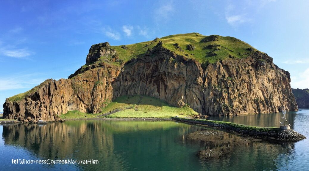
Heimaklettur is the biggest rock in the jumbled chain of cliffs wrapped around the harbour of Heimaey, the main island of the Vestmannaeyjar archipelago south of Iceland. It looks inacessible, but it is possible to climb all the way to the top. In this article I will give you a detailed description of the Heimaklettur hike on Heimaey. The views from the top across the islands are incredible!
Prettiest harbour entrance in Iceland
The Heimaey harbour entrance is stunningly beautiful. People coming in on the ferry are often triggered into a photo-frenzy when they sail into it, through a narrow passage along mountainous rocks. They shelter the harbour like a protective arm from fierce tides and rogue winds coming in from the north. Heimaklettur rises up at the end of it, and sits proudly across from the harbour, watching over it.

Heimaklettur and the harbour entrance.
The Home Rock
At 279 meters, Heimaklettur is the tallest mountain on Heimaey, and the defining landmark of the island. Its bulky shape is visible all around town. Heimaklettur literally means ‘Home Rock’.
Sheer cliffs, ladders and chains
With sheer cliffs rising up on all sides, Heimaklettur may look a bit daunting and inaccessible at first sight. But there is actually a walking track to the top. And there are ladders and chains to help you up the steep sections at the bottom.

Wilderness Coffee on the rocks!

Hiking track on the upper part of Heimaklettur.
Climbing up to Heimaklettur
I made a detailed description of the Heimaklettur hike, including lots of photos of what the track is like. This will give you a good idea of what to expect along the way. I update these articles on a regular basis, so you’ll often find new information and practical tips. When I lived on Heimaey, I hiked up to Heimaklettur many times (including winter), and I keep coming back to Vestmannaeyjar every year.
From the start of the track it takes about 45 minutes to reach the top, and another 30 minutes to get back down again. This is not counting the time you need to enjoy the great views, a picnic or a Wilderness Coffee along the way. 😉

Vestmannaeyjar island shapes.
Vestmannaeyjar, shaped by volcanic activity
The chain of craggy rocks on the north side of Heimaey is the oldest part of the island, forged by volcanic activity from the hotspot underneath about 40.000 years ago. Initially the harbour kletturs and the cliffs around Herjólfsdalur were two seperate islands. Later on they were connected by Eiðið, the narrow strip of land between them. Stórhöfði, the peninsula in the south, was formed as a third island about 6000 years ago. When Helgafell arrived to the scene, all three were merged together into the present island.
The shifting and changing is still an ongoing process. Only as recent as 1973 Eldfell made its sudden and spectacular entrance, when it erupted out of nowhere in a grassy field next to Helgafell.

In case of emergency, dial 112… 😉
Starting point of the Heimaklettur hike
The gravel path up to Heimaklettur starts at Eiðið, behind the narrow end of the harbour. It takes about 20 minutes to walk to the start of the track from the ferry harbour and the central part of town. The first part of the track involves a series of ladders against the steep lower cliffs. Once you’re up above the ladders, you will reach the grassy slopes and rolling meadows that lead to the top.
The walking track can be a bit tricky in some places, with narrow paths, steep drop-offs and provisional steps carved into the rocks. There are chains attached at crucial points, to help you along the more precarious parts. But it should not be attempted in howling winds or horizontal rain. Or if you are sensitive to vertigo or fear of heights.
The wind can be really treacherous in Iceland, and especially on Vestmannaeyjar!

This track contains steps and ladders – not to mention ropes and chains…
Warning signs
A new sign has been placed at the bottom of the first ladder, to inform hikers and encourage them to take care and responsibility when they go up the track. If at any point you feel unsure about continuing, whether it’s a case of wobbly knees or a sudden bout of nasty weather rolling in, you always have the choice to turn back. It’s no fun being blown off the mountain, or slide down a steep grassy slope into the harbour.
But don’t let that discourage you. The Heimaklettur hike is a spectacular and exhilarating walk, where you can enjoy stunning views on all sides along the way. Especially when the weather is good – and not too windy!

Looking down the steep slopes above the harbour.
The ladders up to Heimaklettur
After scrambling up the gravel heap at the bottom of Heimaklettur, you’ll reach the ladders set up against the steep and rocky lower cliffs. The first and second ladder are connected by small plateaus.
Above the second ladder, a path of wooden steps leads across a grassy slope full of wildflowers up to the third ladder. This is the part where it gets tricky and you have to scramble up the notorious sheepcage cliff.

The second ladder and steps.

The first set of ladders at the top of the gravel slope.

Steps up to the third ladder.
The notorious sheepcage ledge
The third and last ladder goes up to a ledge with a (usually empty) sheepcage. The sheep are roaming freely around the grassy meadows further up on Heimaklettur. When you come in on the ferry, you can often see them grazing on the steep mountainsides above.
The ladders on Heimaklettur were installed in the early 2000’s. You don’t even want to think about what it was like to climb up Heimaklettur before that time…
There’s a chain and a rope attached onto the ledge below the sheepcage, and some small steps carved out in the rocks just on the left of the ladder.

The third ladder leading up to the sheepcage ledge.

New and improved ladders and steps
Up until a decade ago, this last ladder didn’t reach all the way to the top of the ledge. You had to balance on the upper steps to get hold of the ropes, braving wobbly knees and decide if you felt confident enough to make this rather big leap. With nothing else but the rope to hold on to while doing so…
But now the old rickety ladder has been replaced by a new and improved version that reaches comfortably above the ledge. This makes it a lot less complicated to get hold of the ropes and step onto the ledge. After that, the rest of the way up is relatively easy.
Still, it’s probably the trickiest part of the track. And don’t forget: on the way down you’ll have to do this in reverse, and lower yourself from the ledge onto the ladder again…

Looking up to the sheepcage.

Ropes and chains on the ledge below the sheepcage.

Pleasant grassy ridge on the side of Heimaklettur
If you feel unsure about continuing at this point: there is a nice alternative. Heimaklettur has a broad & pleasant grassy ridge near the bottom of the sheepcage ladder, just around the corner to the right. It’s an excellent place to enjoy a picnic and great views over the harbour and town.
Usually it’s quite sheltered from the wind too, and worth a little side-trip at any rate.

The grassy ridge to the right of the sheepcage ladder.

The dazzling view from the end of the ridge to Langa, the grassy hill and beach below Heimaklettur.

Klif, the beacon rock, on the other side of the Eiðið isthmus.
The track above the sheepcage
After a relaxing break on the grassy ridge, it’s time to finally conquer the daunting sheepcage ledge and continue on the track further up. The track beyond the sheepcage until you get to the upper slope is very narrow and rocky in places. There are chains attached to some of the steeper and trickier parts.
Once you’re on the upper slope, it’s mostly fine.

The path above the sheepcage.

More narrow & rocky tracks, some with chains attached to the side.
The intersection halfway up
After the rocky parts along steep sides you’ll reach an intersection of paths and sheep tracks. Here you take a sharp turn to the left. Soon after, you will reach the broad and grassy upper slopes of Heimaklettur.
There are a few sheep tracks circling around Heimaklettur, but the path to the top is quite obvious once you’re on it.

Traffic jam on the track may occur at any time… 😉

Grassy meadows on the upper slope, with a view to the Eldfell lava field.
Puffins flying around Heimaklettur
In summer you can often see lots of puffins sitting on that stubby rock sticking out on the left near the top of Heimaklettur. They are also flying around the slopes down the other side, towards Miðklettur and Ystiklettur near the harbour entrance.
The best time to see them is late in the evening before sunset.

Steep drop-off to the seaside… the notorious Dufþekja.
Heimaklettur guestbook
At the top of Heimaklettur there’s a guestbook to leave your thoughts and impressions of this beautiful walk. Some locals frequently write in it; they go up on a regular basis as a way of exercise. And perhaps some friendly competition amongst each other as well – to see who has gone up the most times within a year. When the sun goes down, the guestbook area is a popular hangout spot for the local sheep too. 😉
Heimaklettur is the only Vestmannaeyjar peak with its own guestbook. The light on top also doubles as a beacon for incoming and outgoing regional planes.

Guestbook, airplane beacon and sheep hangout at the top.

Ring of kletturs and lava fields panorama.
Ring of kletturs and harbour rocks
Don’t miss the hidden view behind the top! Beyond the guestbook, walk a little further down the slope towards the harbour entrance. You’ll be greeted by a stunning view over the other kletturs, forming a beautiful circle of cliffs around the harbour. Here you can really see why this is the most beautiful harbour entrance in Iceland.
On clear days you can see the main land with Eyjafjallajökull and Hekla in the distance, and the vast lava fields coughed up by Eldfell in 1973.

The light is getting beautiful… And if the sheep can go there, then so can I! 😉
Heimaklettur hike summary
Distance: 2 kilometres return from the Eiðið carpark.
Time: About 1 to 1,5 hours.
Heimaklettur summit: 279 metres above sea level.
Difficulty: Challenging. Steep and exposed sections with ladders, ropes and chains.
Heimaklettur map
This handy interactive map shows the walking route from Eiðið up to the top of Heimaklettur. You can also zoom in for more details of the track, and click on the icons for pictures of stunning views along the way.
Note: The map is a bit distorted because of the steepness of Heimaklettur… You can see some details when you zoom in, but it doesn’t really show the finer details of the track itself. See the photos further up in this post for that. But there’s only one way up and down Heimaklettur, so you won’t get lost.
@ This is one of the top-5 blog articles of 2017, and a reader’s favourite every year since.

Where the mountains sing through the screams of seagulls…
And the magic nights surpass all others… í ‘HeimaEyjan’ mínn… 😉
Other tracks & hikes on Heimaey
If you’re up for another klettur, you can continue on to Klif, the one with the flat top and the beacon on the other side of Eiðið. Or go up behind Klif to the HáHá plateau, for the stunning ridge walk around Herjólfsdalur.
Not sure if Heimaklettur is the right track for you? There are plenty of other walking tracks around Heimaey. And not all of them involve ladders or ropes and chains.

Looking towards Klif and Dalfjall across from Heimaklettur.

Candles light the way in the impending darkness.
Candles on Heimaklettur
When the days grow shorter, candles are often placed on the slopes along the cliffside facing town. These candles are lit by dedicated locals who frequently go up to Heimaklettur – so people in town can enjoy some pretty lights blissfully shining during the darker days of the year. It’s a quirky and enchanting Vestmannaeyjar tradition that has been going for over a decade. Some of the regulars even have their own ‘candle spot’.
Chrismas and New Year’s extravaganza
Usually you can spot one or two candles. But around Christmas and New Year it gets totally out of control, when Heimaklettur is decorated with a multitude of candles all over the upper slopes. It’s an incredibly beautiful sight.

Christmas and New Year’s candles on Heimaklettur.
Candles on mountains
A contagious Vestmannaeyjar tradition
I was fascinated by the candles on Heimaklettur since I first came to Vestmannaeyjar. It inspired me to become an avid candle lighter too. I took part in the New Year’s Eve candle lighting session in 2017, and went & lit candles on several other kletturs as well.
I’m proud to contribute to this unique local tradition. Kveikjum eldana! 🔥
@ If you are wondering what this is all about, find out more in my story about the candles on mountains on Vestmannaeyjar.

I’ve added my own candles a couple of times too… 😉
@ Read how to travel to Vestmannaeyjar in this article.
Where is Vestmannaeyjar?
Vestmannaeyjar is a volcanic chain of islands just off the south coast of Iceland, directly across from Eyjafjallajökull. They are also known as the Westman Islands. The main island of Heimaey may look tiny on the map, but there’s a lot of spectacular scenery densely compressed into its 13,4 square kilometres. The ferry to Heimaey departs from Landeyjahöfn harbour and takes 35 minutes. You’ll see the turn-off to Landeyjahöfn near the Seljalandsfoss waterfall on the Ring Road.
@ If you have any questions, let me know in the comment section below. I’d love to hear from you! Your questions, comments and suggestions are also helpful for other readers and travellers. Thank you for sharing.
Follow Wilderness Coffee & Natural High on Facebook and Instagram for more stories.

View over Heimaey harbour from the ridge on Heimaklettur.
Videos
Midnight sun in Iceland
The sunset views from the top of Heimaklettur are absolutely magical. This is what the midnight sun looks like… Luminous clouds & pink skies throughout the night – it’s like fiery red & orange northern lights! The video was taken around 01:30 hrs on Solstice night (20-21 June 2018), with an amazing view to Eyjafjallajökull across on the other side. The sun took a short break down the horizon at 23:40 hrs, and was up bright & shining again at 03:05 hrs.
Fireworks in the sky, above and below
The first New Year’s Eve fireworks on Heimaey, while the last sunset of the year is simultaneously blasting a firework in the sky. View from the top of Heimaklettur during the NYE candle lighting session (2017).
More to explore & discover
Vestmannaeyjar – Þar sem hjartað slær (A spectacular island and festival)
Ode to the mountains – The magic of Mount Taranaki
Island hopping on the Aeolian Islands – A volcanic archipelago
Dalalæða – Spectacular waterfalls of fog
Thórsmörk – Rjúpnafell and the hidden valley
© All photos and content on this website are my own, and subject to copyright (unless credited otherwise). Please contact me if you want to use a photo or quote a text from one of my articles. You’re welcome to share a link to my blog articles and photos on social media, with a tag and mention to Wilderness Coffee & Natural High.
This article was first published on 2 July 2017.
10 thoughts on “The walking track to Heimaklettur – The Home Rock”
Love this article and it’s the deciding factor for me to visit the island in the beginning of September! Will there be anything blooming during that time or will it be transitioning to fall? Or better question, are there any interesting plants I should keep an eye on during that time period? I plan on hiking Heimaklettur then over to Klif, Blátindur, and down to Stafsnes if the weather is good. Hope you are having a great day!
Hi Jasen, thank you for your compliment. I’m happy to see that my blog has inspired you to check out Vestmannaeyjar – it’s definitely worth the trip. And the beginning of September is a great time to visit. There will be autumn colours everywhere, and beautiful flowing light – as you can see in the picture above the Heimaklettur hike summary.
An added bonus is that you will be there in the middle of the Puffin Patrol season on Heimaey! It’s a unique island tradition, where the locals are looking for stray puffin chicks and trying to catch them, to release them into the sea. This happens for about 2 to 3 weeks between mid-August and mid-September – see my article about Stórhöfði for more about that. You’ll not only see puffins, but also crazy geological formations along the way.
You can also take a car on the ferry to Vestmannaeyjar. And if you haven’t booked your car rental yet, you can get a special 5% discount with Blue Car Rental via this link – I highly recommend them.
The Facebook group ‘Plants of Vestmannaeyjar’ has a lot of pictures and information about all that grows & blooms on the island.
Have a great time climbing the kletturs on Vestmannaeyjar!
Hi Nancy, thanks for sharing this detailed overview of the hike. We used it to get a good impression before we started the hike. I linked to your page from our website. Best regards, Sporty Travellers
Hello Sporty Travellers! I’m happy to share my stories, and to see that it helped you prepare for the hike up to Heimaklettur. How did you like the views from up there? Thank you for your comment and recommendation.
Dear Nancy, my 14 year old son and I (47) plan to go to Iceland this summer and we want to spend one or two days on Vestmannaeyjar. Your blog fascinates and inspires us very much. Thank you so much for the great stories and also the lovely photos! We would love to do the walking track to Heimaklettur, but I am a bit afraid of heights. Especially the third ladder seems to be a challenge. Do you think I could handle Heimaklettur anyway? I have a normal physical constitution. Or is the walking track to Herjolfsdalur the better alternative for us? It seems to be possible to prevent frightening situations there. We look forward to hearing from you! Best regards, Birgit.
Hi Birgit, thank you for your compliment, nice to see that you enjoyed my stories and pictures. 🙂
It can indeed be a bit of a challenge to climb Heimaklettur if you’re afraid of heights. The best thing to do is to judge your own feelings once you’re there. See how it goes, and take it one step (and ladder) at a time. If you feel unsure or not confident enough, don’t continue. The step between the third ladder and the sheep cage ledge is the trickiest part. It may be even harder to do this in reverse on the way back down; that’s what I personally find the most difficult. The picture with the ropes and chains on the ledge gives you an idea what it looks like. The track beyond the sheep cage until you get to the upper slope is also very narrow and rocky in places. Once you’re on the upper slope, it’s mostly fine.
Of course it also depends on what the weather will be like. If it’s very windy, I wouldn’t recommend going up to Heimaklettur. The wind can be really treacherous in Iceland, and especially on Vestmannaeyjar!
Herjólfsdalur is also an awesome hike to do. Keep in mind that the Eggjarnar ridge above the valley has some narrow & rocky parts too. But even if you don’t go up there, this valley is beautiful from every angle. The coastal track to Stórhöfði is another excellent option. It starts from the bottom of Herjólfsdalur. You can see lots of puffins along the way, and a beach full of crazy geological structures.
Whatever track you decide to do, you won’t find a shortage of beautiful hikes around the island. Enjoy your time in Iceland and on Vestmannaeyjar! And let me know if you made it to Heimaklettur. 🙂
I am visiting next year and just making a list of possible things to do (I like to be prepared) and I think I am up for this. My knees are not great, but I am active and think I could manage this. My main on concern would be doing it alone, and with camera equipment on my back. But as it will be June, hopefully I’ll have plently of time to enjoy this – I like a challenge and am not afraid of heights, will just take it slow and hope for a decent weather day of just a light Icelandic breeze 🙂 & hopefully see some puffins along the way.
Thanks for this post – I’m hoping it will be fairly obvious what way to go and won’t need to refer to this as I climb!
Hi D, thanks for your comment! June is an excellent time to visit. There will be huge fields of lupines everywhere, and you’ll see those incredible colours of the midnight sun. Make sure to plan at least a couple of days on Heimaey if you have the chance, as the weather can be a bit unpredictable & changable. You won’t regret it – there is so much to see!
There are a few sheep trails circling around Heimaklettur, but the path for the hike to the top is quite obvious once you’re on it. If you feel uncertain, just take it slow as you go. There are plenty of views to enjoy. The first time I went on Heimaklettur I didn’t make it beyond the sheep cage ladder; it still had the old rickety one that didn’t reach quite high enough, and it was a bit too windy as well. With the new ladder it has become a bit easier to take that step. You can see lots of puffins on that stubby rock sticking out near the top, and also on the slopes behind the top on the other side (where you have the view of the ring of kletturs). Best chance to see them is late in the evening before sunset. Or very early in the morning – but that’ll be in the middle of the ‘night’ in June! 😉
If you want to do other walks around Heimaey, check out this post too:
Vestmannaeyjar walking tracks – The best walks on Heimaey.
Have a great time! This island is truly stunning.
Just a follow up on this! I got back from my trip (postponed from 2020) and had an amazing time! I spent a few days on the island but did this on the day I arrived as the weather seemed favourable. And it was pretty much perfect, definitely needed to take off the 3rd layer once I got to the top!
I did end up on a slight incorrect detour at the intersection, going right instead of left – the little path got smaller and smaller and I realised it was probably just for sheeps, and after two sheep then shouted at me, I took this as an indication to turn back 🙂 Not sure how I missed the correct left turn, but was obvious once I turned back. I just took it slow and rested when I needed to (fairly fit, but not a hiker!), no rush needed.
I didn’t see any puffins unfortunately, but the view was stunning and the weather pretty perfect. Given how my other days panned out, I’m glad I did it on day one as the other days I had free would not have been favourable.
I actually found the descent more precarious, as some of the make shift steps I was able to step up ok, but the knees less reliable on the way down, but again just kept it slow.
I also did Eldell and had my last morning not been heavy constant rain I would have tried Helgafell but it certainly was not the right time!
I’m so glad that I did it, given how long I’d been planning the trip and this being on the list of activities.
Hello D, thanks for dropping back in and sharing your impressions. Great to see you made it to Iceland and Vestmannaeyjar in the end! And that my article has inspired you to go up to Heimaklettur. 😀
Yes, if you keep on going at that intersection (instead of taking the sharp turn to the left), you’ll end up on the sheep tracks towards Miðklettur. But those sheep are great at making nice little paths to explore further…