The walking track to Klif – The beacon rock
Klif is the bulky and flat-topped rock with a beacon of light on the top, on the island of Heimaey (Vestmannaeyjar). You can haul yourself up the stunning cliffs of Klif along ropes and chains attached to the upper parts. That may sound a bit discouraging, but the hike is actually a lot of fun. It’s not as difficult as it looks, and well worth the effort. In this article I will show you the ropes! 😉
Sculpted cliffs and jumbled rocks
Klif stands across from Heimaklettur on the other side of the Eiðið isthmus. Steady erosion on the seaside has resulted in beautifully sculpted cliffs with several nooks and crannies. They are filled with a multitude of jumbled rocks, tiny beaches and bizarrely shaped spires rising up from below.
Some of these spectacular views can only be seen from the top of Klif.

Fields of lupines with Klif and Dalfjall in the distance. Klif is the bulky rock on the right.

Ropes on the side of Klif.

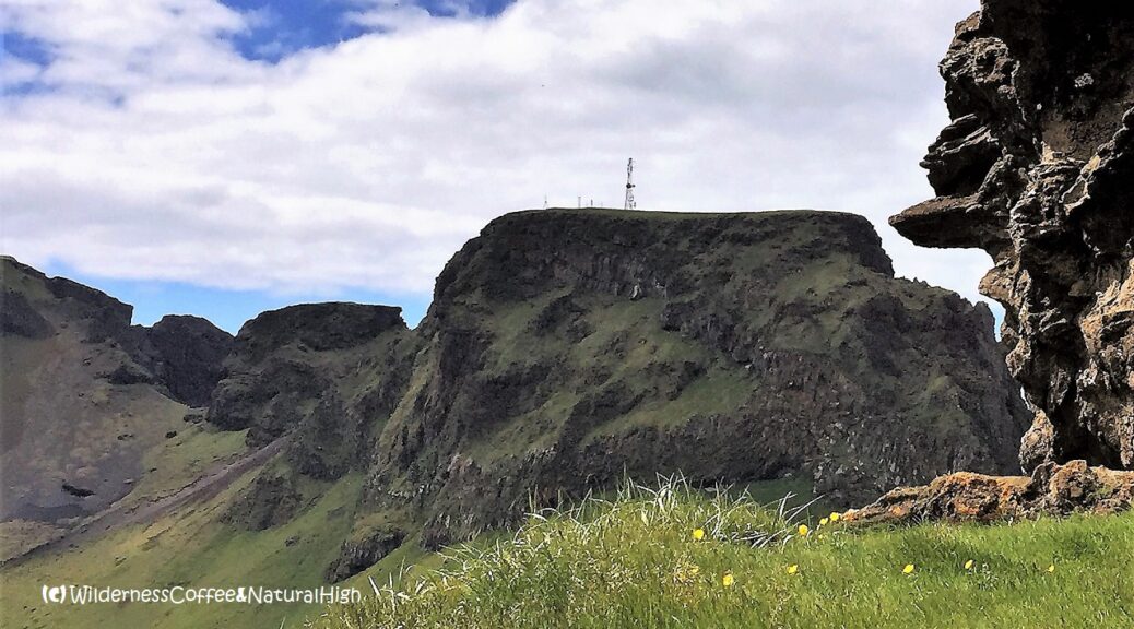
Beautiful views to Heimaklettur and Eyjafjallajökull on the way up.
Islands shaped by volcanic activity
Klif rises up at the eastern end of the intricate formation of jumbled rocks and craggy cliffs that stretches out via the HáHá plateau to Herjólfsdalur, Dalfjall and Blátindur. Together with the harbour cliffs they are the oldest part of Heimaey, forged by volcanic activity from the hotspot underneath the sea about 40.000 years ago. The rest of Heimaey didn’t emerge until 6000 years ago. The island was constructed by a combination of several eruptions, after Stórhöfði and Sæfjall arrived in the south, and finally Helgafell fused them all together.
Shifting and changing on Heimaey
The shifting and changing of the island is still an ongoing process. Only as recent as 1973 Eldfell made its sudden and spectacular entrance, when it erupted out of nowhere in a grassy field next to Helgafell. The island of Surtsey rose from the sea in 1963 and is the latest addition to the Vestmannaeyjar archipelago.

Friðarhöfn, the narrow end of Heimaey harbour.

The path towards Klif.

View to Helgafell, with some beautiful wispy translucent clouds floating above.
Starting point of the Klif hike
The track up to Klif isn’t clearly marked. The path starts directly across from Friðarhöfn, the narrow end of Heimaey harbour. It’s tucked away behind the N1 petrol station and the new fishing factory that’s being built next to it. You’ll see it when you zoom in on the map further down in this article.
Sheep fence and gravel slope
The path leads from behind the parking lot towards the protrusion of Litla-Klif – that stubby little plug jutting up between Klif and the HáHá plateau. After a few hundred meters it continues behind a sheep fence with a wooden step and up to the slopes of Klif.
The first part is still firm and grassy. But shortly after the slope gets very steep, with increasing gravel, loose sand and rocks along the way. This is where you’ll see the first rope lying in the sand, attached to a rock further up.

Rope hanging down the slope.
Scrambling up to Klif
From here on, there are ropes at several points to assist you in hauling your way up onto the steep, gravelly slope. Even though you might not need them so much going up, you will definitely be happy with those ropes on the way down!
At the end of the loose and gravelly bit you reach the rocky area on the upper slope, with chains and more ropes attached by helpful islanders.

Looking down the slope from above…

The gravelly upper part of Klif.

Don’t forget to enjoy the views along the way…

The last set of chains and ropes up to the top. Almost there!
Spectacular views from the top
And finally, a broad & grassy plateau with flowery meadows awaits behind the electricity station on the top of Klif. Your efforts will be rewarded by this jaw-dropping view of a multitude of jumbled rocks…
It’s one of those incredible views you can only see from above.

A multitude of jumbled rocks.

The mysterious ‘Crocodile’ and a hidden beach.
The Klif plateau
There are several sheltered spots along the sides of the top of Klif. Here you can enjoy a picnic lunch and a Wilderness Coffee in the thick grass, looking out over Heimaklettur, the hustle & bustle of boats, and the ferry coming into the harbour on the other side of the Eiðið isthmus.
On clear days you can see Hekla and Eyjafjallajökull looming on the mainland, and even the silhouettes of Reynisfjall and Reynisdrangar on the coast near Vík towards the east.

Heimaklettur and its hidden beaches.

View to Eldfell from the top of Klif.

View to hidden beaches behind Dalfjall.

Bird cliffs and hidden beaches
Along the sides of the Klif plateau you can take a careful peek over the edge. It reveals steep drop-offs and crumbly cliffs full of seabirds nesting and floating around. If you’re lucky, you might also spot puffins during the summer months.
There are great views over the seaside to small hidden beaches behind Dalfjall. Some of these may be accessible from the back during low tide, such as the mysterious ‘Crocodile’.

Bird cliffs on the Dalfjall side.

Delicate arctic flowers on the top.

Dalfjall and Blátindur, with the youngest island of Surtsey (born in 1963) on the horizon.
Litla-Klif
There’s a small ridge between Klif and the stubby plug of Litla-Klif, where you can walk below its crumbly edges. Unfortunately there’s no path up to the top of Litla-Klif itself. Or at least not one I found… 😉
Once you’ve soaked in all the beautiful views around Klif, you can (carefully) slide your way back down the slopes again.

Series of chains & ropes on the upper path of Klif.

The ridge to Litla-Klif.

Stunning harbour panorama.
Klif hike summary
Distance: 1,5 kilometres return from the harbour at Friðarhöfn.
Time: About 1 to 1,5 hours.
Klif summit: 228 metres above sea level.
Difficulty: Challenging. Steep gravelly sections with ropes and chains.
Klif map
This handy interactive map shows the walking route from Heimaey harbour to the top of Klif. You can also zoom in for more details of the track, and click on the icons for pictures of stunning views along the way.
Other tracks & hikes on Heimaey
Not sure if Klif is the right track for you? There are plenty of other walking tracks around Heimaey. And not all of them involve ropes and chains or scrambling up gravelly slopes.
A candle on Klif
On dark nights and foggy evenings, the red light on the electricity station sometimes seems to float in thin air like an otherworldly beacon. It’s a captivating sight.
And yes, Klif has received its own candle at some point too! 😉

Klif candle & Wilderness Coffee in the snow.
![]()
Can you spot the candle…?
@ Read how to travel to Vestmannaeyjar in this article.
Where is Vestmannaeyjar?
Vestmannaeyjar is a volcanic chain of islands just off the south coast of Iceland, directly across from Eyjafjallajökull. They are also known as the Westman Islands. The main island of Heimaey may look tiny on the map, but there’s a lot of spectacular scenery densely compressed into its 13,4 square kilometres. The ferry to Heimaey departs from Landeyjahöfn harbour and takes 35 minutes. You’ll see the turn-off to Landeyjahöfn near the Seljalandsfoss waterfall on the Ring Road.

Snowy view from Klif over Heimaey.
@ If you have any questions, let me know in the comment section below. I’d love to hear from you! Your questions, comments and suggestions are also helpful for other readers and travellers. Thank you for sharing.
Follow Wilderness Coffee & Natural High on Facebook and Instagram for more stories.

Náttmálaskarð – sunset through the gap between Klif and Dalfjall.
More to explore & discover
Stromboli – The ancient lighthouse of the Mediterranean
The Hazards – Scrambling up to prehistorical views
Pico del Teide – A volcanic playground
The opal fields of Lightning Ridge – The mesmerizing draw of luminous stone
Eldfell – Volcano erupting a rainbow
© All photos and content on this website are my own, and subject to copyright (unless credited otherwise). Please contact me if you want to use a photo or quote a text from one of my articles. You’re welcome to share a link to my blog articles and photos on social media, with a tag and mention to Wilderness Coffee & Natural High.
Snowy view from Klif
A snowy surround view from the top of Klif on a blissfully calm & wind-free winter morning. This was just after sunrise – around 11 o’clock…!
This article was first published on 19 December 2017.