The walking track to Helgafell – The twin volcano
Helgafell offers sweeping surround views of brooding volcanoes and a heart-shaped crater. But poor old Helgafell is often a bit overlooked, as everyone flocks to its famous neighbour Eldfell. Hike to the top and you may have Helgafell with its beautiful views virtually for yourself.
Classic volcano island
For a long time, Helgafell was the ruling volcano on Heimaey. The one that merged the chain of rocks around the harbour to the north and Stórhöfði to the south into the present island, its classic volcano-shaped silhouette dominating the interior.
Until Eldfell turned up right next to it in 1973, and stole the show.

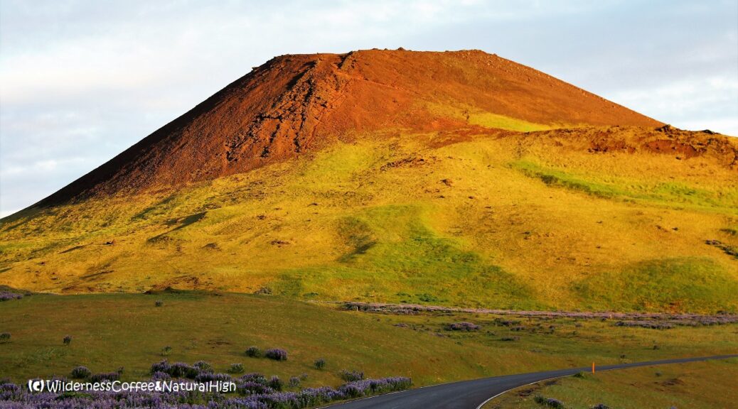
Helgafell basking in the colours of the midnight sun.
Shaped by volcanic activity
Heimaey is the main island in the volcanic chain of Vestmannaeyjar. Most of it didn’t even exist a few thousand years ago. Only the harbour rocks with Heimaklettur, and Dalfjall with Klif and Blátindur had already been around for a while. They were formed as two seperate islands about 40.000 years ago.
Stórhöfði bubbled up from the sea as an island by itself 6000 years ago, during a period of intense volcanic activity when most of Heimaey was moulded into its present shape. Then Helgafell arrived right in the middle and fused them all together with its expansive lava flows.
After that, the volcanoes on Heimaey were dormant for 5000 years, until the arrival of Surtsey and Eldfell last century.

The twin volcanoes Helgafell and Eldfell shimmering on the edge of Vestmannaeyja town.
The twin volcano
The impressiveness of Eldfell is undeniable. But on busy days it can also be a bit of an ant heap, with lots of people going up & down the tracks and circling around its crater, all at the same time. Especially in high season and when there’s a cruise ship in the harbour.
In the meantime, you may have Helgafell with all its beautiful views virtually for yourself. Helgafell has a heart-shaped crater and a viewdial on the top, with the names of the mountains that can be seen in all directions.
The track up to Helgafell can be somewhat challenging in parts, due to its steepness and loose gravelly bits along the way. But it doesn’t take that long to hike to the top.

Midnight sunset on Helgafell and lupine covered lava fields.

The former red house at the foot of Helgafell.
Starting point of the Helgafell volcano hike
To get to the foot of Helgafell, walk up to Heiðarvegur, the main road leading south from the harbour. Pass by two of the only three sets of traffic lights on the island, and after about 15 minutes you reach an intersection. The Helgafell signpost at this intersection points to the house with the same name.
The hiking track itself starts a little further on. Continue on the road towards the airport (Flugvöllur) and then take the next path to your left. You will see another sign behind the football field pointing towards Helgafell.
Helgafell house
Update: Sadly, this cute historical red house is now demolished. A new (white) house has been built on the same site in 2022.

View to the famous Eldfell. Sometimes it looks a bit like an ant heap, with lots of people circling around its tracks and crater at the same time…

Arctic flowers on the slopes of Helgafell.
Climbing up to Helgafell
Follow the grassy path towards the north side of Helgafell until you see a steep and rough path going up. Before you take on the rocky upper slope, you can turn left into a grassy field for some beautiful views of Eldfell and the nearby islands of Elliðaey and Bjarnarey. The ominous Eyjafjallajökull volcano is looming in the background on the mainland.
It gets a bit grittier on the upper part of Helgafell. In the meantime, arctic flowers are taking hold and blooming in spite of adversity on the gravel slopes.

The rocky and gravelly slopes of Helgafell.

Sweeping view from the top of Helgafell.
Broad and sweeping views
Once you get to the top, broad and sweeping views unfold all around you. Behind Helgafell there’s a breathtaking view towards Eldfell, the lava flow that came from it, and the remains of the fissure that erupted out of nowhere.

Looking towards Herjólfsdalur and Klif.

The famous ones – Eyjafjallajökull and Eldfell looming in the background.

Fine views all around from the top of Helgafell.
Heimaey airport
To the south there are views to Surtsey and the outer islands, Stórhöfði peninsula, Litlhöfði and Sæfjall behind the Vestmannaeyjar airport. Yes, Heimaey actually has its own airport – its landing strip barely fitting across the island.
Surtsey is the furthest island on the horizon, and the latest addition to the Vestmannaeyjar archipelago. It rose from the sea in 1963.

Looking out over the airport, Stórhöfði and the islands to the south.

The crater rim path, leading up to the viewdial.
Heart-shaped crater
The track around the crater rim leads up to the viewdial, where you can check out the surrounding scenery. You can walk around and into the crater, and enjoy a picknick and a wilderness coffee in a sheltered spot. Take the same track on the north side to go back down towards the town again.
There’s another track circling down from Helgafell on the south side of the crater rim. It eventually comes out on Fellavegur, the road between Helgafell and Eldfell.
The first part of the track going down is quite steep and full of loose gravel, but it quickly gets more even along the side. Not long after, you are back at the grassy meadow at the foot of Helgafell.

Colourful panoramic views to mountains, volcanoes and islands all around.

The heart-shaped crater of Helgafell. ❤️
Helgafell hike summary
Distance: 2 kilometres return from the information sign on the airport road.
Time: About 1 to 1,5 hours.
Helgafell summit: 227 metres above sea level.
Difficulty: Moderate. Some steep and gravelly sections near the top.
Helgafell map
This handy interactive map shows the walking route from the intersection near the old Helgafell house to the top of the Helgafell volcano. You can also zoom in for more details of the track, and click on the icons for pictures of stunning views along the way.
@ This is one of the top-5 reader’s favourites of 2020.
Other tracks & hikes on Heimaey
Want to explore more of these spectacular views? Here you can find a variety of walking tracks around Heimaey. The biggest challenge is choosing one… 😉

Moonrise, sunset & candles
Helgafell also provides a stunning background when the full moon is rising from behind it in the summer. And if you’re lucky, you might be treated to the incredible spectacle of dalalæða fog waterfalls…!
On my first hike up to Helgafell I noticed a candle in the lava near the top, and thought it was a rather odd place to light a candle. At that time, I didn’t know that there’s actually a tradition of putting candles on mountains on Vestmannaeyjar.
A candle in the lava on Helgafell.

@ Read how to travel to Vestmannaeyjar in this article.
Where is Vestmannaeyjar?
Vestmannaeyjar is a volcanic chain of islands just off the south coast of Iceland, directly across from Eyjafjallajökull. They are also known as the Westman Islands. The main island of Heimaey may look tiny on the map, but there’s a lot of spectacular scenery densely compressed into its 13,4 square kilometres. The ferry to Heimaey departs from Landeyjahöfn harbour and takes 35 minutes. You’ll see the turn-off to Landeyjahöfn near the Seljalandsfoss waterfall on the Ring Road.

A Christmas candle on Helgafell. 😉
@ If you have any questions, let me know in the comment section below. I’d love to hear from you! Your questions, comments and suggestions are also helpful for other readers and travellers. Thank you for sharing.
Follow Wilderness Coffee & Natural High on Facebook and Instagram for more stories.

Winter sunset on Helgafell.
More to explore & discover
Fagradalsfjall – The spectacular Iceland volcano
Vestmannaeyjar walking tracks – The best hikes on Heimaey
Mount Titlis – Alpine meadows & mountain views
Dalalæða – Spectacular waterfalls of fog
Cook Islands – The stuff of Pacific dreams
© All photos and content on this website are my own, and subject to copyright (unless credited otherwise). Please contact me if you want to use a photo or quote a text from one of my articles. You’re welcome to share a link to my blog articles and photos on social media, with a tag and mention to Wilderness Coffee & Natural High.
Amazing sunset on Helgafell
A beautiful winter sunset & surround view from the top of Helgafell.
This article was first published on 28 July 2017.
One thought on “The walking track to Helgafell – The twin volcano”