The walking track to Herjólfsdalur – The Valley of Magic
The valley of Herjólfsdalur is intimidatingly beautiful, whichever angle you look at it. It looks like a giant natural amphitheatre, with stupendous rocks rising up on all sides as you enter the valley. There’s also a walking track on the ridge above. In this article I will give you a detailed description of the Herjólfsdalur hike on Heimaey.
Hiking over Dalfjall to Herjólfsdalur
The track from Heimaey harbour up the backroad to Herjólfsdalur and Dalfjall is one not to be missed. It circles around the ridge above Herjólfsdalur, and the density of spectacular sights and features is just incredible. There are glorious views in all directions, and down the other side of the ridge to crumbly cliffs rising up from the sea.
Choosing pictures for this article was quite a task, because all the views just wouldn’t fit in here! 😉 So you’ll just have to experience the Herjólfsdalur hike & see it for yourself.

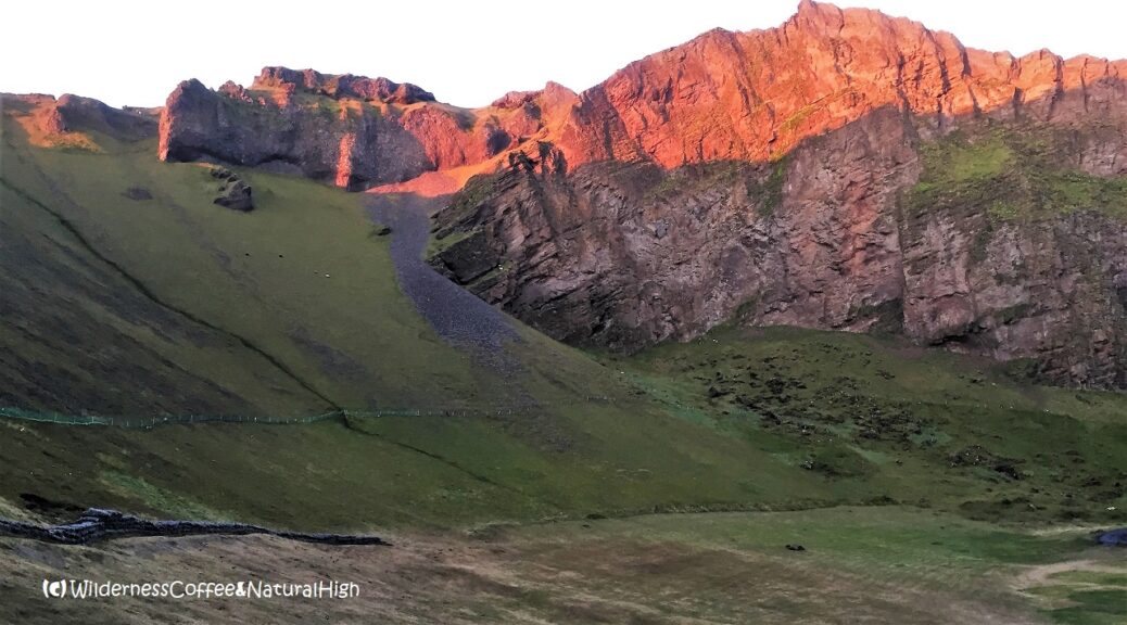
The Valley of Magic. It’s intimidatingly beautiful, whichever angle you look at it.

The path into Herjólfsdalur.
Different options for the Herjólfsdalur hike
The hike around and above Herjólfsdalur can be done in both directions. The easiest way is to start from the back of the cliffs rising up at the narrow end of the harbour. You don’t need to haul yourself up on ladders or ropes for this walk. Although there are some rocky and very steep sections, especially on the path up or down in the valley itself.
If you’re really lucky, you might even encounter this magical sight…

The distraction rate is very high… 😉
Distraction rate
It takes about 1,5 to 2 hours to complete the main track up and around the Herjólfsdalur ridge at a leisurely pace. But the distraction rate is very high. It’s beautiful around every corner along the way. And there are lots of hidden side-tracks to explore if you feel so inclined – and confident enough. Most of these are hardly more than sheep trails, winding their way around steep slopes and jumbled rocks.

The start of the track at Sprangan.

Spectacular nighttime views!
Starting point of the Herjólfsdalur hike
The path towards Herjólfsdalur starts near the harbour at Sprangan. Here you can also have a go at rope swinging. You’ll often find some activity going on during the summer. Kids trying out their skills, a passing tour group with the guide demonstrating how it’s done, and sometimes even a film crew using the location for a movie or documentary.
Sprangan is traditionally used by locals to practice rope swinging, as a way to scale the cliffs and collect bird’s eggs from the more challenging sites around the island.
Sprangan constructions
There’s all kinds of construction going on at the moment, so things may look different in the future. To get on the right track, take the path from Hlíðarvegur up the grassy slope behind the new buildings. From there, you can go to Sprangan across the field on the right. Or continue behind the assorted industrial equipment and turn left up to the hill towards Herjólfsdalur.

The path up to the HáHá ridge leading to Herjólfsdalur.

View to Vestmannaeyja town and the Pointy Black Rock.
Lofty heights
The path gradually slopes up between the cliffs until it reaches a high plateau, aptly named HáHá (no joke!) The name literally means ‘high-high’, to distinguish its lofty height from the lower ridge that is simply called Há.
After about 15 minutes of steadily slogging up the hill, you’ll reach an intersection with a rocky path veering off to the left and right.
Dramatic views
Both of these tracks go up to the same cliffside. The path on the left leads to a sudden and even more dramatic view. It ends rather abruptly at the top of the jagged cliffs on the eastern side of Herjólfsdalur. From the edge you look straight down into its intimidating depths.
It’s incredibly beautiful. Although people who are prone to vertigo might not appreciate the views that much…

The throne above Herjólfsdalur.

View to Heimaklettur and Eyjafjallajökull from the HáHá plateau.

View to crumbly Klif.
Puffins and sea birds
Bunches of small arctic flowers cling to their edges in the face of adversity. Various seabirds are circling around the valley, floating on the thermals it creates. It’s a mesmerizing sight to watch.
You might also see puffins flying around or sitting on the rocks ahead, especially in the evening during the summer months.

The intimidating depths of Herjólfsdalur.

Puffins on the slopes.

Herjólfsdalur cliffs and a kamikaze bird.
Lush gullies and crumbly cliffs
You can walk further along this ridge towards the HáHá plateau and have stunning views into the bowl-shaped valley. Or continue on the path below, to the right of the intersection.
The HáHá plateau has a broad grassy meadow that stretches out to the right of the track. It offers beautiful views towards the crumbly cliffs of Klif and and Litla-Klif, Heimaklettur and the harbour rocks, and into eroded gullies with jumbled rocks and bizarrely shaped spires rising up from below.

Lush gullies with jumbled rocks and little beaches.

Seabirds circling around the gullies.
The Herjólfsdalur ridge track
From HáHá, the track winds down sharply along the sides of Herjólfsdalur. Along the way there are dizzifying views to rocky outcrops and the gravity defying boulders within the valley.
The grassy outcrop to the left is a perfect place to enjoy a Wilderness Coffee, and watch the puffins on the slopes below.

Path winding down into Herjólfsdalur, with some spectacular views coming up.

Eggjarnar step
A small wooden step marks the start of Eggjarnar, the Herjólfsdalur ridge section. From here you can choose the upper path along the top of the ridge, or the safer path on the hillside below.
Be aware that the upper path is eroding away in some places.

The step across to Eggjarnar and the lower path into Herjólfsdalur.

The upper path and Herjólfsdalur ridge.

The path across the ridge
The upper path is definitely the most spectacular. It offers tantalizing glimpses into crumbly holes and the cliffs below, with sculpted sea arches and tiny beaches nestled between rocks jutting out into the sea. However, the path itself can be crumbly in some places too.
You have to be especially careful on sections with loose gravel.

Puffins behind the Herjólfsdalur ridge.

More peeks into crumbly holes from the upper path.

Sea cave, the mysterious ‘Crocodile’ and Ufsaberg, the giant plug.

The steep slopes of Herjólfsdalur.
Small & gravelly paths
The upper and lower path join together just before the gravelly section above the steep slope into Herjólfsdalur. The track then continues along the top of the ridge towards Blátindur, the big peak at the end of it. There are a couple of tricky bits where the path winds precariously around rocky outcrops and bizarrely shaped lava forms. But the views are absolutely stunning in all directions.
Don’t forget to look back every now & then!

Herjólfsdalur ridge track.

Some tricky sections along the way…

As I gaze upon the Valley of Magic, I shall fear no heights… 😉
Zigzag path into Herjólfsdalur
At the end of the Eggjarnar ridge above Herjólfsdalur you’ll see a steep zigzag path going down the slope. It weaves around some huge boulders to the bottom of the valley and ends near the golf course and a small playground.
From there it takes about 15 minutes to walk back into town on the main road, to the left as you come out of the valley.

The steep path up to the Herjólfsdalur ridge.

The zigzag path at the end of the ridge.
The famous sea elephant
If you turn right and continue along the golf course at the base of Dalfjall, you will get to the famous Elephant Rock of Heimaey. It sits on the western end of the bulky group of peaks, peacefully sipping water from the sea. The best views are from a boat trip around the island, but you can also see it when you follow the track along the coast to the south. You can actually spot two elephants on the rocks! The famous one (Fílinn) is the furthest out to the sea.
This beautiful coastal track eventually leads all the way to Stórhöfði, the peninsula and puffin colony in the south of Heimaey.
!")
The famous ‘Elephant Rock’ on Heimaey.
Herjólfsdalur hike summary
Distance: 2,5 kilometres one-way from Sprangan.
Time: About 1,5 to 2 hours.
Highest point: HáHá at 220 metres above sea level.
Difficulty: Challenging. Steep sections and narrow gravel paths on the ridge.
Herjólfsdalur map
This handy interactive map shows the walking route from Sprangan up and around the Herjólfsdalur ridge. You can click on the icons for pictures of the stunning views along the way.
Note: The map looks a bit distorted because of the steepness of Herjólfsdalur, but you will see more details of the track when you zoom in closer on each section. The pictures further up in this post will give you an idea what it looks like.
@ This is one of the top-5 reader’s favourites of 2018 and 2019.

The intimidating steepness of Blátindur.
Other tracks & hikes on Heimaey
You can also go down the other side of the Herjólfsdalur ridge, to the little house at the bottom of Ufsaberg – that giant plug sticking out towards the sea. This path leads further down to the hidden beach of Stafsnes. Or, if you’re still on a natural high and up for another challenge, continue up to the imposing steepness of Blátindur.
Not sure if these are the right tracks for you? There are plenty of other walking tracks around Heimaey. Not all of them involve scrambling or balancing your way across tiny paths above steep drop-offs…
Northern lights above Herjólfsdalur! 😀

@ Read how to travel to Vestmannaeyjar in this article.
Vestmannaeyjar music festival
Herjólfsdalur is also the setting for the yearly Þjóðhátíð festival on Heimaey in August. On the last evening, the mountainside is set alight with a row of flames along the entire length of the valley. A truly magnificent sight to see!
Where is Vestmannaeyjar?
Vestmannaeyjar is a volcanic chain of islands just off the south coast of Iceland, directly across from Eyjafjallajökull. They are also known as the Westman Islands. The main island of Heimaey may look tiny on the map, but there’s a lot of spectacular scenery densely compressed into its 13,4 square kilometres. The ferry to Heimaey departs from Landeyjahöfn harbour and takes 35 minutes. You’ll see the turn-off to Landeyjahöfn near the Seljalandsfoss waterfall on the Ring Road.
@ If you have any questions, let me know in the comment section below. I’d love to hear from you! Your questions, comments and suggestions are also helpful for other readers and travellers. Thank you for sharing.
Follow Wilderness Coffee & Natural High on Facebook and Instagram for more stories.

More to explore & discover
Vestmannaeyjar – Þar sem hjartað slær (A spectacular island and festival)
Ode to the mountains – The magic of Mount Taranaki
Mount Titlis – Alpine meadows & mountain views
Tongariro – The track across Middle Earth
Island hopping on the Aeolian Islands – A volcanic archipelago
© All photos and content on this website are my own, and subject to copyright (unless credited otherwise). Please contact me if you want to use a photo or quote a text from one of my articles. You’re welcome to share a link to my blog articles and photos on social media, with a tag and mention to Wilderness Coffee & Natural High.
Surround view above Herjólfsdalur
It’s also beautiful in winter. Here’s a snowy surround view from the HáHá plateau, just before it descends into the ridge track. This video is filmed with a drone flying over most of the track, and gives a great impression of the walk across Eggjarnar and HáHá.
This article was first published on 16 November 2017.
5 thoughts on “The walking track to Herjólfsdalur – The Valley of Magic”
If you have any questions, please post them directly in the comment box below.
—
I received this question by email from Janet (USA):
‘I was wondering if there are trail markers for the Herjolfsdalur hike. If not, is there a place to get a trail map? Our group is coming from the US and are making a day trip to the island to complete the hike based on your post. Just don’t want to get lost!’
Here’s my reply – so others with similar questions can read this too: @ ‘There are no trail markers along the track, but the path is easy to follow; you won’t get lost. If you start from the harbour, walk up to Hlíðarvegur road and towards Sprangan. When you’re past the new buildings, you’ll see the path going up the hill. Just keep following the path all the way up towards the big plateau and the section where it winds down into Herjólfsdalur. There are also two tracks going up and down inside the valley itself – both are very steep!
At the ferry terminal you can get a map of Heimaey with some trail markings on it (although these are not very clear). Have a great trip to Iceland & Vestmannaeyjar!’
Im born in Vestmannaeyjar and was walking those trails as a kid. I love this page Nancy has made.
Thank you for your support, Heimir. I’m glad you are enjoying my site. Have you seen my post about the northern lights? That was when me and my friend were staying in Stykkishólmur. 🙂
You can read it here: Northern Lights – Hunting the elusive Aurora Borealis.