The zen of Stafsnes – The hidden beach
Tucked away in the northwest corner of Heimaey you can find the beautiful hidden beach of Stafsnes. It sits in a sheltered cove behind the impressive folded cliffs of Blátindur. The only way to get there is by boat, or to hike down the steep slopes behind Herjólfsdalur. In this article I will give you a description of the hike to Stafsnes on Vestmannaeyjar, with plenty of pictures of the views along the way.
Stafsnes peninsula and beach
Stafsnes can be blissfully sheltered (and wind-free!), and significantly warmer than the rest of the island. It’s almost like Hawaii – but without the palm trees… 😉
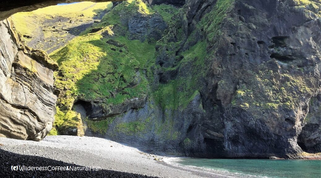
Part of this pebbly beach is beneath an overhanging cave. The cave displays layers of vivid colours when sunlight sparkles off the incoming waves onto the cave walls. The peninsula of Stafsnes stretches out beyond the cave and around the bay. It’s a popular spot for nesting puffins in the summer months.
Tantalizing little glimpses
Tantalizing glimpses of Stafsnes can be spotted only if you brave the walking track to Blátindur. You can see it down the coastline just before you reach the gravel slope and the seemingly dead end below the first ridge of Blátindur. Other than that, its not visible from anywhere else on Heimaey.

Looking down to the hidden beach of Stafsnes from behind Blátindur.

Stafsnes beach in its sheltered cove.
How to reach Stafsnes beach
The easy way to see Stafsnes is by private boat and go around the back of the island. Local boat operator Ribsafari pops into Stafsnes cove on some of their island trips, so you can get a close-up look. As an added bonus you also see various sea caves around the other islands. However, you don’t actually go on shore at Stafsnes beach on these boat trips.
The other way to get to the hidden beach of Stafsnes is to shuffle down the sliding slope on the sea side of Blátindur. This involves climbing up the steep slopes of Herjólfsdalur, and down towards the coast on the other side. If you want to enjoy & and explore the beach at leisure, the only option is to walk.

The Dalfjall peaks in Herólfsdalur. Stafsnes beach is hidden behind this formidable formation, where you can also spot the famous ‘Elephant Rock’.
Starting point of the Stafsnes hike
There are several ways to combine this hike with one of the other beautiful walking tracks on Heimaey. You can do it as an extension of the Herjólfsdalur ridge track, go up to Blátindur first and then to Stafsnes, or the other way around. The most direct way is by going up on the zigzag path from the bottom of Herjólfsdalur. You can see this path on the left side of the slope as you look into the valley.
From the bottom of Herjólfsdalur it takes about 45 minutes to an hour for the hike to Stafsnes. Going back might take longer, depending on your walking speed. The section from Stafsnes to the ridge above Herjólfsdalur is the steepest part – you’ll have to conquer at least 200 metres of sheer altitude.

Sea view of the rugged coastline around Ufsaberg at the bottom of Blátindur.

The little house on the giant plug
Once you reach the intersection of hiking paths on the Herjólfsdalur ridge, you’ll see a small grassy track going down, towards a giant rocky plug protruding out to the sea.
This striking feature is called Ufsaberg. There’s a solitary little cabin at the bottom that makes you want to stay there overnight, and watch the sunset from the veranda while enjoying a Wilderness Coffee in this idyllic location. And – when it gets dark enough – the densely starry skies and perhaps even northern lights flowing in as a bonus…

Stafsnes cabin and a Wilderness Coffee.

Sunset view over Stafsnes from the cabin.

The solitary cabin on Ufsaberg.
Sliding down to Stafsnes
There are a few rudimentary marker sticks on the upper part of the track from the Herjólfsdalur ridge down towards Stafsnes. But it progressively fades into a sheep trail as you slide further down the hill towards the cabin.
You will most likely encounter various sheep wandering around too in this area. Sometimes they’re even hanging out on the cabin’s veranda!

Sheep watching over the veranda.

A peek inside the solitary little cabin.
The track behind Dalfjall
On the east side of Ufsaberg there are stunning views down the rugged and convoluted coastline of Heimaey, towards Klif and Eyjafjallajökull in the distance. Here you can also spot that other hidden beach, nestled behind ‘The Crocodile’.
From the grassy field below the cabin, a small track descends steeply further down to the rocky Stafsnes peninsula and its hidden beach.
Update: The lower part of this track partly collapsed in the winter of 2022. You can still continue to Stafsnes, but it involves yet a bit more sliding challenge…

Convoluted coastline on the north side of Heimaey, with the hidden ‘Crocodile beach’.

Stafsnes peninsula, with a Ribsafari jetboat coming into the cove.

The hidden beach of Stafsnes
As you enter the bay, you are welcomed by breathtaking views of towering folded cliffs and into the narrow cove. Beautiful panoramas unfold around every corner! Stafsnes beach is peacefully nestled between the cliffs behind Blátindur and an overhanging cave at the base of the peninsula. Aquamarine waters are lapping blissfully around their colourful edges. In the distance, the southern islands are lounging on the horizon.
From the beach it takes another 20 minutes to go all the way to the end of the peninsula. Take the rocky part on the sea side of the peninsula and avoid the grassy areas on the top, as this is where the puffins are nesting in their burrows during summer.

View into Stafsnes cove.

The hidden beach – Pure bliss!

The cave overhang.

Hawaiian style folded cliffs towering above Stafsnes.
Swimming at Stafsnes
Swimming is not recommended at Stafsnes beach. Not only for the risk of hypothermia in the cold Arctic currents, but also because there can be strong undercurrents and unexpected freak waves rolling around the cove. A cross at the base of the peninsula reminds of the tragic death of a young boy who was dragged out to sea and drowned at Stafsnes…
However, the beach is a great place to explore & enjoy the beautiful surroundings, have a picnic, and even sunbathe (!) on warm sheltered days.

Beautiful coastline and tidal pools with cloud reflections.

Ufsaberg peak and Stafsnes peninsula, with the cross in the distance to the right.
Skies full of puffins
Birds like this isolated spot too. There are huge amounts of them circling above the cliffs and into the bay, including puffins, a variety of sea birds and flocks of eider ducks floating around on the waves.
On summer evenings you can see skies full of puffins, returning to their burrows on the peninsula. Stórhöfði on the other side of Heimaey is another popular puffin hangout.
It’s worth sticking around at Stafsnes for the sunsets too – they are magical.

View towards Stafsnes peninsula.

Skies full of puffins at Stafsnes.
Stafsnes hike summary
Distance: 4 kilometres return from Herjólfsdalur.
Time: About 2 to 2,5 hours to Stafsnes beach.
Plus another 45 minutes return from Stafsnes beach to the end of the peninsula.
Highest point: 150 metres up to the ridge above Herjólfdalur, then another 200 metres down to Stafsnes beach.
Difficulty: Challenging. Very steep sections up and down.
Stafsnes map
This handy interactive map shows the walking route from Herjólfsdalur up to the ridge and down to Stafsnes. You can also zoom in for more details of the track, and click on the icons for pictures of stunning views along the way.
@ This is one of the top-5 reader’s favourites of 2018.
Other tracks & hikes on Heimaey
Want to explore more of these spectacular views? Here you can find a variety of walking tracks around Heimaey. And not all of them involve scrambling up or sliding down steep slopes. The biggest challenge is choosing one… 😉

Stafsnes peninsula and Smáeyjar, the little islands on the northwest coast of Heimaey.
@ Read how to travel to Vestmannaeyjar in this article.
Where is Vestmannaeyjar?
Vestmannaeyjar is a volcanic chain of islands just off the south coast of Iceland, directly across from Eyjafjallajökull. They are also known as the Westman Islands. The main island of Heimaey may look tiny on the map, but there’s a lot of spectacular scenery densely compressed into its 13,4 square kilometres. The ferry to Heimaey departs from Landeyjahöfn harbour and takes 35 minutes. You’ll see the turn-off to Landeyjahöfn near the Seljalandsfoss waterfall on the Ring Road.
@ If you have any questions, let me know in the comment section below. I’d love to hear from you! Your questions, comments and suggestions are also helpful for other readers and travellers. Thank you for sharing.
Follow Wilderness Coffee & Natural High on Facebook and Instagram for more stories.

Sunset at Stafsnes.
More to explore & discover
Haleakala – The House of the Rising Sun
Hinchinbrook Island – Unspoiled tropical wilderness
Cook Islands – The stuff of Pacific dreams
The Hazards – Scrambling up to prehistorical views
Stromboli – The ancient lighthouse of the Mediterranean
© All photos and content on this website are my own, and subject to copyright (unless credited otherwise). Please contact me if you want to use a photo or quote a text from one of my articles. You’re welcome to share a link to my blog articles and photos on social media, with a tag and mention to Wilderness Coffee & Natural High.
Videos
The zen of Stafsnes
Waves peacefully lapping in the sheltered cove of Stafsnes.
Stafsnes puffin bird cliffs
The impressive folded cliffs towering above Stafsnes beach, with lots of seabirds and puffins flying around.
This article was first published on 15 February 2018.
2 thoughts on “The zen of Stafsnes – The hidden beach”
Hello, your blog is wonderfull. Can you tell me how long does this trail take time? Thank you.
Hi Selma, thanks for your comment. From the bottom of Herjólfsdalur I would count on at least 45 minutes to an hour for the hike to Stafsnes, if you stop at the beach. It takes another 20 minutes or so to go all the way to the end of the peninsula. Going back might take longer; the section from Stafsnes to the ridge above Herjólfsdalur is the steepest part. Take care & enjoy!
P.S.: If you go in July or August, you can see skies full of puffins in the evening. 🙂