Thórsmörk – Rjúpnafell and the hidden valley
Rjúpnafell is one of the steepest mountains in Thórsmörk, and the hiking track to the top of it is not to be underestimated. It’s a two-headed beast that is frightening and awe-inspiring at the same time. In this article you can read about this route – and what to watch out for.
Hidden gems of Thórsmörk
The fabled valley of Thórsmörk is the stuff of fairytales and epic sagas. It’s so beautiful that it almost seems unreal. Thórsmörk is full of folded valleys and convoluted canyons, glaciers with volcanoes underneath, and bizarrely shaped mountains.
The hike to Rjúpnafell reveals some of the hidden gems within the valley.

The path towards Rjúpnafell.
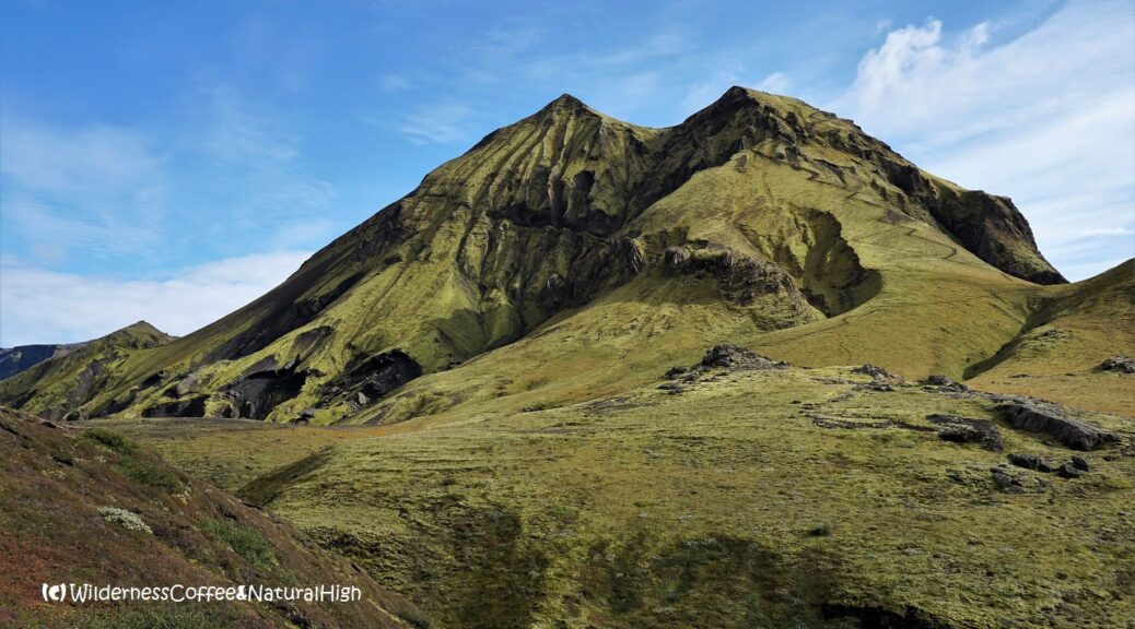
The distinctly shaped Mount Rjúpnafell
Rjúpnafell looms large on the north side of the Krossá river. At an altitude of 824 metres, it has a distinctive two-headed peak and rivals with Útigönguhöfði in terms of mind-boggling steepness. There’s a sweet litte river valley hidden along the track below its slopes, only revealing itself just before you reach it.
I had seen this intriguing mountain in the distance on my previous trips to Thórsmörk. And now I just had to climb it too. 😀

Rjúpnafell looming across the valley of Thórsmörk.
Word of warning: The path up to the first peak does get a bit scary at some point! You need to be very cautious when going up there. If you suffer from vertigo or fear of heights, don’t even try to attempt it. If the top is covered in clouds or if it’s windy on the higher ground around the base of the mountain, it’s not a good idea either. This is one of the scariest mountains I’ve climbed. At one point I even thought I was stuck at the top…
More about that further on in this article.

The Stangarháls lookout point.
Thórsmörk panorama
But even if you don’t climb all the way to the top, the walking track to Rjúpnafell is worth it for the enchanting hidden valley alone. Not to mention the other spectacular panoramic views you will see along the way.

Views along the Stangarháls track on the north side of the Krossá river.
Hiking to Rjúpnafell in Thórsmörk
The Rjúpnafell hiking track leads off from the main Thórsmörk loop, near the Langidalur hut on the north side of the valley. It takes about 5 to 6 hours to the top and back from Langidalur. From Básar or the Volcano Huts in Húsadalur it’s another half an hour to reach the start of the track.
Add 1 or 2 more hours if you want to return via the Trollakirkja and Slyppugil canyon on the Thórsmörk loop.

Signpost to the Rjúpnafell hiking route along the Thórsmörk loop.

Krossá river footbridge.
Footbridges over the Krossá river
From the Básar side you have to walk across the stony riverbed and cross the Krossá over two footbridges, placed at varying locations depending on where it flows. Once you’re on the north side, follow the ridge up to Stangarháls. All along the edges you will find some of the famous views over the valley. Continue across the rolling mossy fields towards Trollakirka.
The troll’s church is further along the Thórsmörk loop, but you will see a rickety wooden sign pointing towards Rjúpnafell before you get to the church.

Rjúpnafell hiking route towards the hidden valley in Thórsmörk.
The hidden river valley
The track goes up and down across more rolling ridges. Then it bends around a steep corner and suddenly the hidden river valley comes into view. It’s a beautiful picnic spot, a sheltered little garden of Eden with a burbling river circling around it. There are even some tiny trees.
A perfect place to sit down & enjoy the surroundings before taking on the steep zigzag path up to Rjúpnafell.

The hidden valley below Rjúpnafell.

A little garden of Eden.

The scary stuff
The zigzag path itself is quite doable, but there is a lot of loose gravel along the track. Things start to get realy tricky where the zigzag path ends, just below the first peak. I followed an increasingly smaller path to a point where it barely clung to the edge of the rock.
It just faded out into nothingness in front of me, and I realized I’d gone too far.

The scary bit! & petriying depths below. The right path is actually on the other side of the rock to the right…
Petrifying depths and steep slopes
My heart started fluttering and pounding as I looked down into the petrifying depths below. I’m not easily discouraged by tiny paths along steep mountain sides, but at that moment I felt a sudden bout of the wobbly knees coming on. ‘This can’t be right’, I thought, and crawled straight up to the rocks above, holding on for dear life. Loose bits & pieces of came off underneath my feet.
How on earth am I going to get down this again?!

The path above the first peak of Rjúpnafell.
Breathtaking views
Beyond this daunting first peak a fairly comfortable ridge comes into view. It leads up to the wide grassy slope of the second peak, the actual top of Rjúpnafell.
And the views are (literally!) breathtaking all around.

Ridge between the two heads of Rjúpnafell.

Grand panoramic view from the top of the ridge.
Coloured mountains and intricate canyons
You can see all the way to the coloured mountains of Landmannalaugar and the highlands to the north. And straight across in the face of Katla, with glacier tongues drooping down into intricate canyons.
Sweeping views of folded mountain ranges unfold everywhere you look.

Katla and its many glacier tongues.

The colourful Landmannalaugar mountains in the distance.

Looking down from the top of Rjúpnafell.
Stuck on the top…?
But I couldn’t enjoy those epic views as much as I normally do… The thought of finding a way down again was constantly in the back of my mind. I was trembling at the thought of those loose rocks and sliding down that horrifying steep slope with nothing to hold on to.
What if I really am stuck on this mountain? Would I have to call 112 and beg for a helicopter to please come and pick me up?
Útigönguhöfði suddenly seemed easy compared to this.

The hiking track to the top of Rjúpnafell… Where did the path go?!
The two-headed monster
A shower of rain approached in the distance, adding even more drama to the landscape – and my state of mind. It came straight towards the top of Rjúpnafell. Oh no… now there’s going to be wet and slippery rocks as well as loose ones…
I sat down on the sheltered side of the top, overlooking the ridge, and waited for the shower to pass. Trying to mentally encourage myself for the way back down. Meanwhile, I heard some deep and distinctive rumbling coming out of Katla. A few times. Glacier movement? Or… was it something else?
No! I’m not going to panic! Panicking won’t help me out. I must stay calm & focussed…
I’m not going to die on this mountain!

Katla, distinctly rumbling in the distance a few times…

Path into the abyss…
The way back down from Rjúpnafell
So I gathered myself together and walked across the ridge towards that dreaded first peak. And found to my great relief that there was actually a slightly better path going down to the right. It was just on the other side of the rock I had crawled on the way up.
As I was concentrating on the path in front of me, I had apparently missed this subtle track going up just a little before it faded out…

The rock below the first peak. On the right side of the track down again!

View to Tindfjöll, the peaky mountains.

Rain showers over Thórsmörk valley.
Shuffling down the track
It was still tense and tricky to shuffle down, and I sighed a grateful sigh of relief when I was finally below the first peak again. Thankfully I kept my mind focussed & refrained from panicking when scaling that terrifying rock.
Lessons learned & affirmed:
- Take one step at a time. If it’s in the wrong direction, go back and try another. You will eventually get where you need to be.
- Trust your instinct & inner compass (even though it’s wonky sometimes…)
- Do not let fear take over your common sense.
I celebrated my survival with another relaxing stop in the garden of Eden on my way back.
And a glass of wine under the northern lights back at the hut that evening! 💚

Northern lights above the Básar hut in Thórsmörk.
Rjúpnafell hike summary
Distance: 18 kilometres return from Básar, 14 kilometres return from Langidalur.
Time: About 6 to 7 hours.
Rjúpnafell summit: 824 metres above sea level.
Difficulty: Very challenging. Steep, gravelly tracks and tricky ridges…
Rjúpnafell & Thórsmörk map
This handy interactive map shows the hiking route I took from Básar up to Rjúpnafell and the hidden valley in Thórsmörk. You can also zoom in on the different sections of the track for more details.
@ See this article for practical tips & information about Thórsmörk, how to get there and where to stay.

Dramatic clouds over Rjúpnafell.
@ What was your scariest mountain experience? Let me know in the comment section below. I’d love to hear from you! Your questions, comments and suggestions are also helpful for other readers and travellers. Thank you for sharing.
Follow Wilderness Coffee & Natural High on Facebook and Instagram for more stories.

Enjoying the views, but still feeling slightly apprehensive at the thought of going down…
More to explore & discover
The coastal track to Stórhöfði – Puffin colony and geological beach
Pico del Teide – A volcanic playground
Faroe Islands – Atlantic weather systems moving overhead
Stromboli – The ancient lighthouse of the Mediterranean
The opal fields of Lightning Ridge – The mesmerizing draw of luminous stone
© All photos and content on this website are my own, and subject to copyright (unless credited otherwise). Please contact me if you want to use a photo or quote a text from one of my articles. You’re welcome to share a link to my blog articles and photos on social media, with a tag and mention to Wilderness Coffee & Natural High.
Rjúpnafell and the hidden valley
Looking out over the hidden river valley beneath the slopes of Rjúpnafell, as it comes into view along the hiking track.
This article was first published on 25 November 2018.
2 thoughts on “Thórsmörk – Rjúpnafell and the hidden valley”
When going up after the zig zag, the path should be to the left? Thank you.
Hello Veronica, nice to see you again here in the comments! 🙂 Yes, when the zigzag path fades out, you need to turn left just before you reach the big bald rock sticking out. It’s the first picture below the paragraph ‘The way back down from Rjúpnafell’. Look for the path to go up there. Don’t continue straight on across the rock – even though you’ll see another tiny path – as you will then get to the Scary Bit!
Have a great trip to Iceland. Thórsmörk is so beautiful, you’ll be spoiled for choice!