Thórsmörk – The fabled valley
The fabled valley of Thórsmörk is the stuff of fairytales and epic sagas. Nestled behind Eyjafjallajökull in the land of the gods, it’s so beautiful that it almost seems unreal. In this article you can find different options and practical information for your hiking adventures in Thórsmörk.
Sculpted by the forces of nature
Thórsmörk is full of folded valleys and convoluted gorges, glaciers with volcanoes underneath and bizarrely shaped mountains. They are sculpted by volcanic forces, intricate rivers and giant glacial floods coming out of Eyjafjallajökull and Katla, who lies restless underneath Mýrdalsjökull glacier.
You have to see it for yourself to believe it’s real.

Magical sunset over Thórsmörk.
Where is Thórsmörk?
Thórsmörk – in Icelandic spelled as Þórsmörk – is a hidden valley on the south coast of Iceland. It’s located at the end of the mountain road F-249 that goes inland from the Seljalandsfoss waterfall, between the small towns of Hvolsvöllur and Vík. In these towns you can stock up on food and other necessary supplies before venturing off into the valley of Thór.
It’s a remote place; you won’t find many options to eat & drink once you’re there.

Fluffy bog cotton and wildflowers.
Hiking in Thórsmörk
Thórsmörk is an incredible hiking paradise. There are walking tracks going off in all directions within and across the valley, with varying degrees of length and difficulty. You could spend days, even weeks exploring them all.
Below are some of the specatacular hikes that will take you all day (or most of it) to enjoy. The shorter routes are well signposted and easy to follow. The Útigönguhöfði and Rjúpnafell hikes are quite challenging and involve very steep mountains. I created seperate stories for these routes, and you can find the general information & practicalities of Thórsmörk here in this article.
The valley of Thórsmörk is divided by the Krossá river that comes thundering out of Katla’s Mýrdalsjökull glacier. Between Langidalur and Básar there are two seasonal footbridges over the Krossá, placed at varying locations depending on where it flows.

The Krossá and Hvanná river valleys in Thórsmörk.

Seasonal footbridges over the Krossá.
Hikes from Langidalur and Húsadalur
(North of the Krossá river)
- Rjúpnafell and the hidden valley – 6 to 7 hours
- Valahnúkur – 2 hours
- The Thórsmörk loop (Stangarháls, Trollakirkja and Slyppugil canyon) – 4 to 5 hours
Hikes from Básar
(South of the Krossá river)
- Útigönguhöfði and Hvannárgil canyon – 7 to 8 hours
- Lower Fimmvörðuháls loop – 7 to 8 hours
- Lower Hvannárgil canyon – 2 to 3 hours
- Réttarfell loop – 2 hours
- Stakkholtsgjá – 2 to 3 hours

The hidden waterfall in Stakkholtsgjá canyon.

Rjúpnafell and the hidden valley
Rjúpnafell is one of the steepest mountains in Thórsmörk. It sits on the north side of the Krossá river, and the hiking track to the top is quite challenging. But you will be rewarded with sweeping views of glaciers and colourful folded mountain ranges all around. There’s also a sweet litte river valley hidden along the track below its slopes.
Hiking time: About 6 to 7 hours return.
Difficulty: Very challenging. Steep, gravelly tracks and tricky ridges…

Útigönguhöfði and Hvannárgil canyon
Útigönguhöfði is that ridiculously steep mountain you see looming everywhere in Thórsmörk and on the way down from Fimmvörðuháls. Climbing it is as challenging as pronouncing its name… 😉 The impressive Hvannárgil canyon runs below its slopes and together they form a beautiful circuit, with jaw-dropping views from one end to the other. Be prepared for some serious crawling up the rocks on either side!
Hiking time: About 7 to 8 hours return.
Difficulty: Very challenging. Extremely steep & gravelly sections up and down.
Fimmvörðuháls loop
You can also combine either Útigönguhöfði or Hvannárgil with the lower section of the Fimmvörðuháls route, the Thórsmörk volcano hike up to Eyjafjallajökull. This part of the track includes the famous ‘Cat Ridge’ (Kattarhryggir, or cat spine). All of these routes come together on the Morinsheiði plateau above the Thórsmörk valley.
@ Read more about the different routes & options in my article about the Fimmvörðuháls hike.

Kattarhryggir, the ‘Cat Ridge’ on the lower Fimmvörðuháls route in Thórsmörk.
Multi-day hikes from Thórsmörk valley
Thórsmörk is also the starting point (or the finish) of the famous Laugavegur hiking route to Landmannalaugar. Another great walking track is the Fimmvörðuháls route to Skógar, the fiery pass across Eyjafjallajökull. These are demanding multi-day hikes that require thorough preparation (and a bit of luck with the notoriously unpredictable weather).
You will need to carry a backpack full of food for multiple days, warm layers of clothes, a sleeping bag, plus additional camping gear if you’re not staying at the huts. Fimmvörðuháls can be done in a day, but it will take at least 8 to 12 hours to hike the entire route. Staying overnight at the hut on the top of the pass is a great option to break this journey in 2 enjoyable sections.

Hiking towards Thórsmörk on the Fimmvörðuháls route.
Where to stay in Thórsmörk
Even if you don’t want to do any of the hardcore stuff, it’s definitely worth it to base yourself in one of the huts for a couple of days and indulge in the beautiful surroundings of Thórsmörk.
Huts & camping
There are three huts spread out across the valley, all offering basic bunk rooms as well as campsites. The Básar hut is on the Eyjafjallajökull side and the Langidalur hut across on the north side of the Krossá river. The Volcano Huts are in Húsadalur, the next vally to the north. They also have more fancy options such as private rooms, glamping, a restaurant, and even their own natural ‘hot pool’. Reservations for the huts are required, and strongly recommended to do well in advance during the summer season.
In September you might have more short term options and flexibility. The Básar and Langidalur huts are usually open from early May to the end of September. Volcano Huts is open all year.

Northern lights above the Básar hut.
Thórsmörk weather
An added bonus of Thórsmörk is that it’s nearly wind-free most of the time, due to its sheltered location behind the bulky volcanoes of Eyjafjallajökull and Katla. It’s a different story when you get to the higher places. Especially the difference in wind speed between the Morinsheiði plateau and the lower ridges in Thórsmörk itself can be astounding.
The wind in Iceland is not to be underestimated. And if you’ve spent some time in notoriously windy locations (such as Vestmannaeyjar), you will appreciate the absence of it even more. 😉
Unpredictable weather changes
Still, the weather can change rapidly at any time. It’s good to have a few extra days to make the most of it, and especially if you want to do some big walks. There’s no guarantee the weather will be favourable on the one day you’ve planned to do your hike. But even in September the weather can still be nice & balmy.

Beautiful autumn colours on a calm day in September.
How to get to Thórsmörk
The F-249 mountain road into Thórsmörk is only accessible for serious 4WD cars and mountain trucks with giant tyres. You will have to cross a myriad of complicated fast-flowing glacial rivers that keep changing their course all the time, fed by streams rushing down from various side-gorges.
The road is usually open for traffic from mid-June to the end of September, depending on weather conditions, river levels and the amount of snow. The Icelandic Road Administration provides information about the opening and conditions of the mountain roads.
Beware of the treacherous Thórsmörk rivers
The main Thórsmörk river crossings are Steinholtsá, Hvanná, and the fearsome Krossá, which can easily become too much to handle for small 4WD’s. Some rivers might look rather innocent at times. But they show no mercy for the unexperienced and unaware. Cars regularly get stuck or swept away. Sadly, there have been some fatal accidents too – so don’t even think of trying to cross the Krossá if you don’t know exactly what you’re doing. The currents can be very strong, even if the river doesn’t look that wide or deep.
You can reach Básar without crossing the Krossá, but not Langidalur and Húsadalur.

Krossá river and Mýrdalsjökull glacier, where Katla sleeps underneath.
Renting a car
You will need a large 4WD with a high clearance, such as a Toyota Land Cruiser or Land Rover type if you want to drive the F-249 to Thórsmörk.
I have rented cars with several companies in Iceland, and I’m really pleased with Blue Car Rental. It’s my go-to company now when I want to rent a car in Iceland. Blue Car offers good quality cars and hassle-free packages with zero deposit and all the main insurances included. They have an office just across the road from Keflavík International Airport and in Reykjavík at the Grandi harbour district. You can fill out your details and check in online, so picking up your rental car is quick and easy.
If you book through this link, you’ll also get a 5% discount on their car rental rates! 🙂


Hvannárgil, the enticing canyon between Útigönguhöfði and the Krossá river.
Bus companies and day tours
Several bus companies offer transfers from Reykjavík into Thórsmörk with big wheel river trucks, such as Trex and Reykjavík Excursions. Usually they operate from mid-June to mid-September, when the tracks are open.
There’s also a variety of exciting day trips with local guides. Midgard Adventure offers a Thórsmörk tour in giant-tyre Super Jeeps from their basecamp in Hvolsvöllur. Southcoast Adventure has several tour options, as well as a scheduled Thórsmörk transfer from Hvolsvöllur.

Epic view from Valahnúkur into the valley of Thórsmörk.
Essential items
Food and water
Always take plenty of food and water when you go hiking in Thórsmörk. You don’t want to find yourself running on an empty battery & out of energy if the hike takes longer than anticipated. It’s better to carry it around for nothing than finding yourself in a dire situation without it.
Powerbank
Speaking of empty batteries, it’s also very convenient to take a powerbank with you, in case your phone or camera battery runs out. Only the Volcano Huts have electricity sockets to plug in your charger. The Básar and Langidalur Huts charge about 1000-1500 ISK to charge your stuff.
Clothing and shoes
Rain- & windproof trousers and jacket are essential, as well as a wooly hat, gloves (yes, even in summer), warm layers of clothes and sturdy hiking boots. If you stay at one of the huts, you need to bring your own sleeping bag. You can’t take your muddy shoes inside the hut, so it’s handy to have a pair of sandals or hut sneakers to wear inside.
Hiking sticks and water shoes
If you’re planning to do the Laugavegur hike, you will also need water shoes. There are several unbridged rivers to cross along this multi-day route. These are all glacial rivers with stony riverbeds that are not very comfortable to cross on bare feet! Hiking sticks are practical to keep your balance when wading through these (often) knee-deep rivers.
Water shoes come in handy for the hike to Stakkholtsgjá as well. You have to cross the Hvanná river by foot to reach the track into this canyon from Thórsmörk.
Thórsmörk map
The handy interactive map below shows several beautiful hiking spots around Thórsmörk. You can zoom in for more details, and click on the icons to reveal pictures of stunning views.
The huts and campsites in Thórsmörk sell detailed maps with all the hiking routes. These maps are also outside on their buildings.
@ This is one of the top-5 reader’s favourites of 2022.

Signposts on the top of Útigönguhöfði.
Hiking & travel safety in Iceland
Always check the weather and track conditions before you go. And be prepared to change your plans if necessary. There have been many cases where people had to be rescued off the track due to exhaustion, disorientation and ignorance of impending nasty weather. You can find up-to-date conditions on Safe Travel Iceland and Umferðin (the Icelandic Road Administration), and their various social media outlets.
These are some examples of warnings about the travel conditions that can occur…
And they are to be taken seriously.
Thórsmörk rivers are dangerous – Extremely heavy rain and water melting from the glaciers. The rivers water levels are very high and extremely dangerous to drive through, even with bigger jeeps. Do not try to cross!
No hiking conditions on Fimmvörduháls – No hiking conditions on the Fimmvörduháls trail due to extreme winds, heavy rain / snow and cold temperature.

Autumn colours and blueberries.
@ If you have any questions, let me know in the comment section below. I’d love to hear from you! Your questions, comments and suggestions are also helpful for other readers and travellers. Thank you for sharing.
Follow Wilderness Coffee & Natural High on Facebook and Instagram for more stories.

My (well-used!) map of hiking routes in Thórsmörk.
(*) This article contains some affiliate links for services I have personally used and recommend. When you book through these links, I may earn a small commission at no extra cost to you. This helps me to run my website and keep on researching practical travel tips & information for you. 🙂
More to explore & discover
La Palma – Cumbre Vieja Volcano Route
Ode to the mountains – The magic of Mount Taranaki
Island hopping on the Aeolian Islands – A volcanic archipelago
The Hazards – Scrambling up to prehistorical views
Most popular stories across all pages – An overview
© All photos and content on this website are my own, and subject to copyright (unless credited otherwise). Please contact me if you want to use a photo or quote a text from one of my articles. You’re welcome to share a link to my blog articles and photos on social media, with a tag and mention to Wilderness Coffee & Natural High.
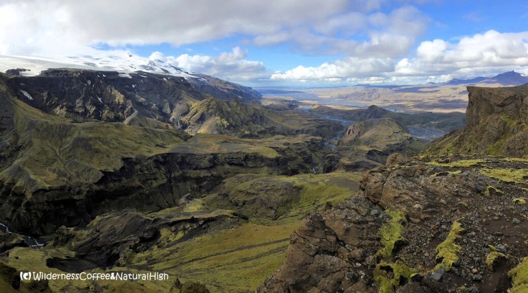
The fabled valley of Thórsmörk
View over the fabled valley of Thórsmörk from the top of Útigönguhöfði.
This article was first published on 11 November 2018.
4 thoughts on “Thórsmörk – The fabled valley”
Thnx voor de mooie blog Nancy, hoewel m’n heimwee naar het mooie IJsland hierdoor alleen maar groter wordt… Alle goeds gewenst!
Haha, ik snap wat je bedoelt, Gus… Het is een welbekend syndroom. Toen ik voor het eerst naar IJsland ging, dacht ik dat dat de enige keer zou zijn… En sindsdien heb ik altijd heimwee! 😉
If you have any questions, please post them directly in the comment box below.
—
I received this question by email from Eric (USA):
‘Hi, I’m an amateur photographer researching a hiking / photography trip to Iceland and have been doing some research on Thorsmork. I’m looking for interesting vantage points over the valley and came across your great webpage. I was wondering if you could tell me which hike would lead me to the area in the photo at the top of this page. I really like the perspective with the cliffs and canyons. Thanks for any information that you can provide. I appreciate it.’
Here’s my reply – so others with similar questions can read this too: @ ‘Hi Eric, thank you for your compliment and for reaching out. I’m glad you enjoyed my blog post about Thórsmörk! The cover photo on this article is the view from the top of Útigönguhöfði, one of the most distinctive mountains in the area. The views from up there are just unbelievable. It’s also a very steep & rather challenging mountain to climb. You can read all about it in my blog post about Útigönguhöfði and Hvannárgil canyon.
You can reach the track to Útigönguhöfði from Básar (huts & camping area in Thórsmörk), and go up and back the same way, or continue down on the other side and return via the Hvannárgil canyon. Which is also very photogenic! But wherever you look around in Thórsmörk, you will see amazing photo opportunities all over the place. It’s such a beautiful area, definitely worth spending a few nights if you have the chance. The whole of Iceland really is a photographer’s paradise, so I’m sure you will enjoy it.