La Palma – Cumbre Vieja Volcano Route
Cumbre Vieja Natural Park offers stunning hiking routes amongst volcanic cones and giant craters. The park was temporarily closed during the eruption in 2021, for obvious reasons. Now that this fierce volcano has settled down again, the Cumbre Vieja Volcano Route is one of the finest walks you can do on La Palma. The route reopened in May 2022.
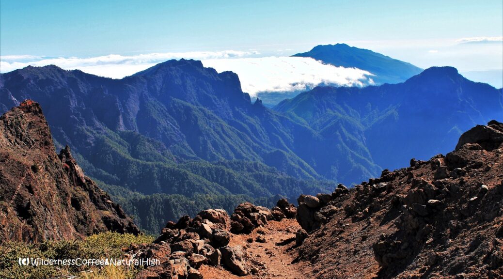
Cumbre Vieja volcanic ridge
Cumbre Vieja is an elongated and steep-sided stratovolcano that covers the entire southern part of the island of La Palma. It stretches out from north to south over a distance of 24 kilometres. On its northern side Cumbre Vieja is connected to Caldera de Taburiente by the Cumbre Nueva central ridge, famous for its perpetual rolling curtain cloud.

The famous curtain cloud of La Palma rolling over Cumbre Nueva.

Clouds rolling over Cumbre Nueva, with Los Llanos de Aridane in the background. The steep slopes of Caldera de la Taburiente are pointing up to the sky on the left.
A wonky ridge sprinkled with many craters
Satellite images on Google Maps reveal a long ridge, riddled with a line of craters scattered all over the top. It looks like a wonky zipper that could rip apart any time. The entire Cumbra Vieja mountain range consists of a mind-boggling 120 (!) volcanoes and craters. 😳
And when it erupts, there are usually several of them going off at once.
@ You can read more about the Cumbre Vieja Volcano Route further down in this article.
The wonky zipper of the Cumbre Vieja ridge. Photo: HelloCanaryIslands (Canary Islands Tourism).
The Cumbre Vieja eruption in 2021
2021 was a crazy year in many ways, not in the least because of the madly erupting volcanoes in Iceland and the Canary Islands…
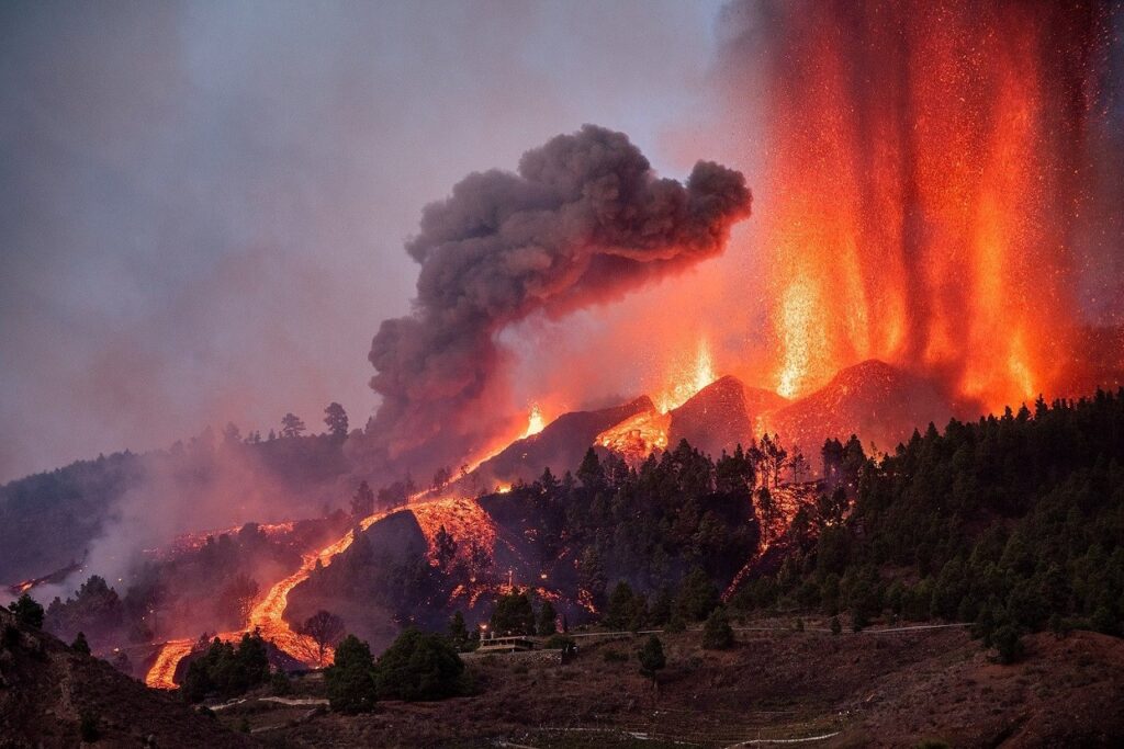
On the same day that Fagradalsfjall in Iceland subsided, the Cumbre Vieja volcano on La Palma cracked open a new crater, and roared into life on 19 September 2021. But this was no friendly flowing volcano like the gentle Fagradalsfjall.
Cumbre Vieja erupting from many craters. Photo: La Voz del Sur.
Lava tumbling down to the ocean
Cumbre Vieja unleashed furious lava fountains and aggressive ash clouds, belching from various craters and vents on its western flank. At one point there were 10 or 11 craters going off at the same time, with angry fire jets spiralling out of control.
The lava flow consumed houses and entire villages within the first couple of days. It tumbled down the mountainside from its original crater at an altitude of 900 metres and plunged into the ocean 6 kilometres further away only 10 days later, on 29 September 2021.

View to Valle de Aridane from mirador El Time. The lava flows have created two new deltas on the west coast of La Palma.

Valle de Aridane before the eruption.
History repeats
It was very reminiscent of the Eldfell eruption on Heimaey in 1973, when the entire island had to be evacuated. And similar to Reykjanes in March 2021, the La Palma eruption was preceeded by an intense swarm of more than 25.000 earthquakes within 3 weeks before it started.
Cumbre Vieja – even the name itself sounds threatening. Ominous like the rumbles from its belly it sent forth with its destructive lava flows.

The Cumbre Vieja eruption in December 2021.

La Palma volcano update
Is Cumbre Vieja still erupting?
The eruption was officially declared over on 24 December 2021 – just in time for La Palma’s residents to celebrate Christmas and New Year with a sigh of relief. On 12 December 2021 the new Cumbre Vieja volcano became the longest eruption in known history on La Palma, after 85 days of continuous activity. The next day it signed off with a final belch of ash and noxious fumes, rising thousands of metres into the air.
Name of the new Cumbre Vieja crater
In the meantime, the volcano has received its own name. It’s now officially called Tajogaite and sits at an altitude of 1120 metres. Tajogaite is the local Guanche name for Montaña Rajada, which appropriately translates as Cracked Mountain. It refers to the area directly downhill from the eruption site, also known as Cabeza de Vaca.
Images from NASA Earth Observatory show a daunting comparison of the area around Valle de Aridane before and after the eruption.

View to the Tajogaite eruption plume from Caldera de Taburiente on 13 December 2021; the last day of its activity.
Cumbre Vieja Natural Park
The Cumbre Vieja Natural Park area offers stunning hiking routes amongst volcanic cones and giant craters. The 24 kilometre long Ruta de los Volcanes (Volcano Route) is one of the most beautiful hikes on La Palma.
When I went island hopping to the Canary Islands on an earlier trip, I hiked the northern part of the Ruta de los Volcanes. I did the section from El Pilar to the intimidating Hoyo Negro crater, and back again along the same track.
This is what Cumbre Vieja looked like before the 2021 eruption.

View to Valle de Aridane from Cumbre Vieja, above the eruption site where the new crater formed in 2021.

Mysterious stone circles on the Cumbre Vieja Volcano Route.

View from Cumbre Vieja to the rolling clouds and the massive Caldera de Taburiente in the north.
Ruta de los Volcanes
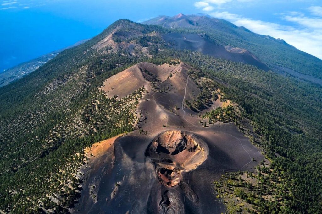
The Ruta de los Volcanes (GR 131, stage 3) is well signposted. It runs from the recreational area El Pilar in the north along the tops of Cumbre Vieja all the way to the Fuencaliente lighthouse in the south. The southern tip also contains the Teneguía volcano, the last one to erupt on La Palma in 1971, until the 2021 eruption began.
The main hiking path is 17,5 kilometres. It takes about 6 hours from El Pilar until you emerge from the wilderness in Los Canarios, the first village on the southern tip of La Palma. There are no facilities between El Pilar and Los Canarios, you so have to be well prepared. Take plenty of food & water with you.
From Los Canarios you can continue on for another 6 kilometres to the very end at Fuencaliente lighthouse.

Ruta de los Volcanes track beneath the rolling clouds of Cumbre Nueva.

Pico Birigoyo on the north side of the Cumbre Vieja Volcano Route.
Cumbre Nueva rolling curtain cloud
The first part of the track from El Pilar goes beneath the perpetual cloud tumbling over the Cumbre Nueva ridge. It’s mesmerizing to see how it weaves in and out between the trees on the meandering path. Then you emerge from the forest up to the first craters of Pico Birigoyo. From there you follow the hiking route all the way south along the Cumbre Vieja ridge.
The views are breathtaking all around. At Pico Birigoyo you can look across the top of the rolling cloud towards the massive Caldera de Taburiente in the north.
Further on to the south you’ll encounter bizarrely shaped crater pits, such as the daunting Hoyo Negro. With the recent eruption still fresh in the mind, it’s intimidating to think of the force and huge amounts of lava that must have come out of that giant black pit. It last erupted in 1949.

The daunting Hoyo Negro crater.
How to hike the Cumbre Vieja Volcano Route
The easiest way to do the Cumbre Vieja hike is from north to south, as you will be walking downhill most of the way. The altitude varies from around 1440 metres above sea level at El Pilar to 1945 metres at the summit of Las Deseadas, the highest point on the Cumbre Vieja ridge.
After that, you descend all the way down to Los Canarios at 725 metres, or the Fuencaliente lighthouse at sea level.

Fuencaliente lighthouse on the south coast of La Palma.

Teneguía volcano near Los Canarios.
Volcanoes of Teneguía Natural Monument
Just outside Los Canarios you can visit the San Antonio and Teneguía volcanoes, the latest additions to the Cumbre Vieja ridge before the 2021 eruption. There are several hiking routes meandering between their lava fields.
Teneguía appeared in 1971, and – in contrary to Tajogaite on Cumbre Vieja – didn’t cause widespread destruction. San Antonio last erupted in 1677 and you can walk around its entire crater rim. The 400 metre wide crater is a testimony to the resilience of nature, as it is now filled with new trees and Canary Pines. Be aware that it can be very windy around the top of the crater.

San Antonio volcano with its tree-filled crater.
Getting to & from the track
If you want to hike the entire Cumbre Vieja Volcano Route, the best option is to park your car in Los Canarios and take a taxi from there to the starting point at El Pilar. If you don’t have a (rental) car, you might be able to arrange transfers from your accommodation.
There are no buses up to El Pilar, but there are connections from the capital Santa Cruz de La Palma to Fuencaliente and Los Canarios with the local TILP bus company.

Signpost along the Ruta de los Volcanes, with a view to Pico del Teide on Tenerife in the distance.
Cumbre Vieja Volcano Route hike summary
Distance: 17,5 kilometres one-way.
Time: About 6 to 8 hours.
Start: El Pilar at 1441 metres above sea level.
Finish: Los Canarios at 725 metres above sea level.
Add-on: Fuencaliente at sea level, 6 kilometres from Los Canarios.
Highest point: Las Deseadas at 1945 metres above sea level.
Difficulty: Challenging.
You can find more information about the Ruta de los Volcanes (and the necessary preparations) on the Canary Islands Tourism website.
La Palma & Cumbre Vieja map
This handy interactive map shows the locations in the pictures above. You can also click on the icons, and zoom in for more details of the island and the Cumbre Vieja ridge.

Ruta de los Volcanes altitude map. Photo: Senderos de La Palma.
How to get to La Palma
International and domestic flight connections
There are direct flight to La Palma from several European countries. Flights to Tenerife and Gran Canaria are more frequent, and often cheaper. From Tenerife and Gran Canaria you can also take a domestic flight to La Palma.
During the eruption, the airport at Santa Cruz de la Palma was regularly closed due to ash clouds and other volcano-related inconvenience. The safest option then was to fly to Tenerife and take the ferry from Los Christianos over to Santa Cruz de la Palma. This is also what I did on my first Canary Island hopping trip, when I wanted to combine Tenerife, La Palma and El Hierro in one go.
Ferry to Santa Cruz de la Palma
From the harbour town of Los Christianos in the southwest of Tenerife you can take regular ferries to Santa Cruz de la Palma. Both ferry terminals are within walking distance of the town itself. Los Christianos is also the departure port for ferries to the other western Canary Islands of La Gomera and El Hierro. Similar to the planes of Icelandair, many of the ferries are named after local volcanoes. 🙂
The Canary Islands Tourism website offers a handy overview of the ferry and plane connections between the islands.

La Palma is famous for its beautiful sunsets and clear skies. On the horizon you can see the epic shadow of Caldera de Taburiente against the sky.

The red rolling curtain cloud, lit up by the glow from the erupting volcano, beneath a sky full of stars.
La Palma island tour
This video shows a nice compilation of various places around La Palma, from a trip I did with two friends in December 2021. It features the final days of the erupting volcano (from 10:37).
You can also see the endless winding road up to Roque de los Muchachos, the highest point on the island – with incredible views of the rolling curtain cloud. Further on there are more images of the volcano-dotted and rainbow-sprinkled south coast around Fuencaliente and Los Canarios.
Video by Freek Slangen.
@ This is the fastest growing reader’s favourite of 2024.

Intricate layers of colourful volcanic deposits on the winding road to Roque de los Muchachos.
Rebuilding has begun
The beautiful island of La Palma is slowly recovering from the devastating volcanic eruption. Already in January 2022 bulldozers and excavators started ploughing through the huge walls of lava. The first part of this daunting task is clearing the road between Tazacorte and La Laguna, and eventually to the beach town of Puerto Naos south of the lava flow.
You can now visit the new volcano on a guided tour. The website of Senderos de la Palma shows the latest updates on the status of the hiking tracks.
Video by El Time, the local newspaper of La Palma.
@ Have you done the Cumbre Vieja Volcano Route? Or been up to the new Tajogaite volcano? Let me know in the comment section below. I’d love to hear from you! Your questions, comments and suggestions are also helpful for other readers and travellers. Thank you for sharing.
Follow Wilderness Coffee & Natural High on Facebook and Instagram for more stories.
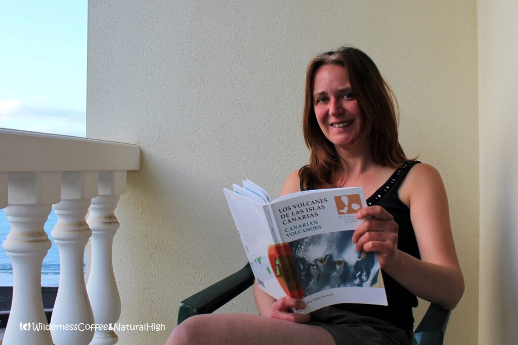
Exploring the inner geekness! An interesting book about the geology of the Canarian volcanoes.
More to explore & discover
Fagradalsfjall – The spectacular Iceland volcano
Island hopping on the Aeolian Islands – A volcanic archipelago
Mount Etna – Vigorously steaming from all its craters
Hawaii – Volcanic fields of fire
Faroe Islands – Atlantic weather systems moving overhead
© All photos and content on this website are my own, and subject to copyright (unless credited otherwise). Please contact me if you want to use a photo or quote a text from one of my articles. You’re welcome to share a link to my blog articles and photos on social media, with a tag and mention to Wilderness Coffee & Natural High.
A song for La Palma
La Palma is crying, with tears of fire… Spanish singer Melendi wrote a song for La Palma. The revenue will go to the affected residents who lost their home due to the eruption.
This article was first published on 22 November 2021.
2 thoughts on “La Palma – Cumbre Vieja Volcano Route”
Good article! I loved the Ruta de los Volcanes years ago and am hoping to go back soon. I wondered if it was open again. Groeten!
Thank you. I’d love to go back too! The Ruta de los Volcanes was reopened in May 2022. You can check the current status on the Senderos de la Palma website; it will tell you if the route is open, if there are any warnings, or if it’s closed due to weather or other safety concerns. Scroll down to GR 131 Etapa 3 – Refugio de El Pilar to Fuencaliente.