Fimmvörðuháls – The fiery pass across Eyjafjallajökull
The Fimmvörðuháls hike between Skógar and Thórsmörk is nothing short of epic. This 26 kilometre route takes you over the fiery pass across Eyjafjallajökull and into the fabled valley of Thórsmörk. On the top of the pass you can see the giant lava fields and new craters from the 2010 eruption.
The Fimmvörðuháls hiking route
But is it possible to do the Fimmvörðuháls route and see all this in one day? In this article I will show you Fimmvörðuháls the easy way, the hard way, and an unexpected grand encore on that ridiculously steep (but utterly beautiful) Útigönguhöfði mountain.

Colourful lava flows from the Fimmvörðuháls fissure.
Fimmvörðuháls eruption 2010
The Eyjafjallajökull volcano is one of the defining features that blew me away on my first trip to Iceland. Back then, I didn’t even know its name, and it was still some obscure mountain massif on the south coast. Until it suddenly erupted into world fame in the spring of 2010. I was proverbially screaming in frustration when I saw all those videos of spectacular lava fountains circulating around the internet.
I so much wanted to see this with my own eyes!
The first episode – now affectionally known in Iceland as ‘the tourist eruption’ – took place right in the middle of the hiking track across Fimmvörðuháls, the pass between the glaciers of Eyjafjallajökull and that other fearsome volcano – Katla.
@ In 2021 I finally had the chance to see an erupting volcano up close, when Fagradalsfjall kicked into life on Reykjanes peninsula!

Mýrdalsjökull glacier, where the fearsome Katla volcano sleeps underneath. On the right is Hrunagil canyon, where lava flows drooped down from Eyjafjallajökull during the 2010 eruption.
The fiery pass across Eyjafjallajökull
So when my next trip to Iceland suddenly bubbled up in 2014, I had to finally climb the thing, and see (what was left of) the steaming heaps at the Fimmvörðuháls fissure. The Fimmvörðuháls hiking route goes from Skógar on the south coast to the other side of Eyjafjallajökull. It drops down into the fabled valley of Thórsmörk, one of the most beautiful and enigmatic parts of Iceland.
Thórsmörk – in Icelandic spelled as Þórsmörk – is a hidden valley behind the bulky flanks of Eyjafjallajökull. It’s full of big mountains, glaciers with volcanoes underneath, huge river valleys and gorges & all kinds of rugged terrain.

Epic view from behind Eyjafjallajökull into the valley of Thórsmörk.
Fimmvörðuháls hike to Thórsmörk
The easy way, the hard way (& a grand encore)
In the meantime, I have done this walk in both directions.
- The easy way up from Skógar to Fimmvörðuháls and down into Thórsmörk (with an overnight stay at the Fimmvörðuháls hut on the top!)
- The hard way up from Thórsmörk to Fimmvörðuháls and back down again.
- Plus an unexpected grand encore over the ridiculously steep but utterly beautiful Útigönguhöfði mountain (more about that further on!)
@ I added a map with all of these routes at the bottom of this article.

Skóga river, just before it plunges down into Skógafoss.
Different options
Is it possible to do the Fimmvörðuháls hike in one day?
The hike between Skógar and Thórsmörk is about 26 kilometres, with an altitude gain from near sea-level to 1044 metres on the Fimmvörðuháls pass. It takes about 8 to 12 hours to complete the entire route. So yes, technically it is possible and some people do it in a single day. But it’s much more enjoyable to split the walk in 2 sections. Then you also have the chance to see an epic sunset over Eyjafjallajökull glacier from the Fimmvörðuháls hut, near the highest point of the pass.
Distraction!
The biggest distraction is the overload of mind-blowing scenery all along the route. You will want to have plenty of time to enjoy it, take photos, and have some leisurely picnic stops too. And you definitely don’t want to feel rushed because you have to catch a bus at the end of the track – the Fimmvörðuháls hike might very well take longer than you expected.
Peronally I can walk quite fast, but I like to take detours, have a Wilderness Coffee along the way, and enjoy the surroundings. And having to rush is one of the biggest spoilers for me. So I always need more time. 😉

Fimmvörðuháls hiking track, with Eyjafjallajökull looming in the distance.

Ice bridge over a river along the route.
Staying in Thórsmörk
Another good option is to stay in Thórsmörk and base yourself at one of the huts for a couple of days. You’ll be in the middle of the spectacular valley, with several walking tracks going off in all directions. If the weather turns out to be no good to take on the long haul up to Fimmvörðuháls, there are plenty of other walks you can do.
Thórsmörk is also the starting point (or the finish) of the well-known Laugavegur hiking track to the coloured rhyolite mountains and geothermal fields of Landmannalaugar.
There are three huts spread out across the Thórsmörk valley. The Básar hut is on the Eyjafjallajökull side and the Langidalur hut across on the other side of the Krossá river. The Volcano Huts are in Húsadalur, the next valley to the north.

The Básar hut at the bottom of the Fimmvörðuháls track in Thórsmörk.
Fimmvörðuháls and Thórsmörk huts
Reservations for the huts are required, and strongly recommended to do well in advance, if you don’t want to haul your camping gear up and down the mountain and spend the night freezing in exposed glacier-surrounded terrain. Especially at the Fimmvörðuháls hut, with limited availability (18 people) and a small window of opportunity. It’s only open from around 15 June to 31 August.
I booked the Fimmvörðuháls hut two months beforehand, and already struggled to find an available date to fit in the travel schedule. If you go in the off-season, you might have more options and flexibility. The three huts in the Thórsmörk valley are usually open from early May to the end of September, and have more space to accommodate people.

Rjúpnafell mountain, on the north side of the Thórsmörk valley.
Thórsmörk weather and practicalities
With the extremely unpredictable weather in Iceland, it can be a bit complicated to plan a specific day and necessary hut reservations for the Fimmvörðuháls route. It’s notoriously fickle on Fimmvörðuháls, and the track can become rather impassable in bad weather.
When a massive fog or a giant dalalæða settles down, it’s easy to become disoriented on the high plateaus and snowfield-covered upper parts of the track. If there are nasty winds funneling through the gorges and raging snowstorms howling around the top of the glacier, it is definitely no fun to do this hike.
Here’s my experience of the Fimmvörðuháls hike in Thórsmörk on both sides.

Walking up to Fimmvörðuháls from Skógar, the gateway to Eyjafjallajökull from the south.
Skógar-Fimmvörðuháls-Thórsmörk
(The ‘easy way’)
Me and my friend did the one-way hike from Skógar to Thórsmörk in June 2014. It’s about 15 kilometres from Skógar to the Fimmvörðuháls hut, and another 11 down the other side into Thórsmörk – the significantly steeper part of the track.
We were a bit apprehensive about how the weather would turn out on the day we started the hike and booked the hut. It would not be a good idea to go up the mountain in case of howling rain or other atrocious conditions. But we got lucky and had nice & sunny weather.
At least on the way up…

Skóga river and its many gorges & waterfalls.

The path of many fosses along the banks of the Skóga river.
Skógar and Skógafoss
The track starts at the bottom of Skógafoss, one of the most famous and iconic waterfalls of Iceland. You can stay overnight at the nearby village of Skógar, or take the early morning bus from Reykjavík. If you have a rental car, you can leave it in Skógar and take the mountain truck out of Thórsmörk to Hvolsvöllur. From there you can take the regular Strætó bus back to Skógar.
Staying overnight in Skógar
The benefit of staying in Skógar the night before is that you can explore the waterfall at leisure in the endless evening, without the usual crowds during daytime. It also gives you the opportunity for an early start of the Fimmvörðuháls hike, so you’re ahead of the crowds coming in on the first bus from Reykjavík.
When I was at Skógafoss in 2006, I had to wait for nearly half an hour for some people to arrive, so I could ask them to take a picture of me in front of the rainbow waterfall. Nowadays it’s no longer like that.

Skógafoss rainbow waterfall without the crowds.
The way up to Fimmvörðuháls
Next to Skógafoss there’s now a comfortable set of iron staircases going up to the ridge above, complete with a lookout platform for some great views onto the mighty waterfall. Beyond here, the track starts gradually sloping up the mountain.
It leads across lush green pastures along the east banks of the Skóga river, plunging down all the way from the Eyjafjallajökull glacier. The river is filled with countless bubbling waterfalls, interspersed with many lookout points into crumbly gorges. The first section of the Fimmvörðuháls hike is also known as the Waterfall Way.

Skóga river gorge and an icesheet with ash from Eyjafjallajökull volcano.

Bridge to the upper parts of Fimmvörðuháls.

One of several snowfields before you reach the Fimmvörðuháls hut.
Snowfields between the glaciers
At about two thirds of the way, the lush green slopes give way to more barren terrain that can get a bit tedious. After 8 kilometres you’ll cross the bridge over the Skóga river and enter the stony desert on the upper part of the Fimmvörðuháls track. Not long after, you have to traverse the first snowfield. Just when you think you’re almost there, another one comes into view, going down and back up again.
There will be at least one or two snowfields more to conquer before you get to the ridge that leads up to the welcoming sight of the Fimmvörðuháls hut. If it’s early in the season, there might be even larger snowfields…

A welcoming sight!

Midnight sunset and a giant dalalæða coming in.

Snowfields and the Fimmvörðuháls hut on the ridge in the distance.
Change of weather
The next day, the weather had changed and was not in our favour. During the night the wind picked up and came howling around the Fimmvörðuháls hut and the exposed ridge it is on. I was nearly blown off the veranda when I opened the door. We had to put on all our layers, hats & gloves and rain trousers.
To my dismay & frustration I had a leaking boot as well, and had to wrap some provisionary plastic bags around my socks to keep them dry.

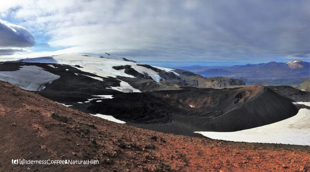
Magni crater still steaming at its edges.
Magni and Móði craters
Not long after leaving the hut, the Fimmvörðuháls fissure comes into view. It really is an intimidating sight – a maze of giant lava flows, spread out over an enormous length and piling up several metres high. The nearby Magni and Móði craters were still steaming at their edges.
I had wanted to go up to the craters and bumble around in them, but the wind was just too brutal to even try & attempt. Unfortunately we had to abandon this little side-trip and focus on battling our way down instead.

Signpost almost buried in the snow…

The notorious Heljarkambur ridge between Morinsheiði and Eyjafjallajökull.
The way down from Fimmvörðuháls into Thórsmörk
After the lava fields the track plunges steeply down into Thórsmörk along a series of plateaus and a multitude of gorges and folded valleys. Some truly epic views unfold before your eyes – if you manage to see through all the wind-induced tears.
We were struggling to stay upright, even with the added weight of 10 kilo backpacks. I had to literally sit and bumslide down some steep sections in order not to be blown off the mountain. Luckily a tour guide came along and offered us some help by providing hiking sticks.
I don’t normally use hiking sticks, but in situations like these they really do come in handy!

The giant Morinsheiði plateau.

Sliding down Morinsheiði.

The lower part of the Fimmvörðuháls hike into Thórsmork.
Ropes & chains and the Cat Ridge
Then we had to slide our way along chains on the sides of steep ravines, until we reached the giant Morinsheiði plateau. Things finally became a bit more pleasant once we got across this plateau. The wind decreased as we descended down onto the sheltered forrested slopes of Thórsmörk. There were still a few tricky sections along the way, but there are ropes attached to help you down steep and rocky inclinations.
Further down is the part where you cross the beautiful Kattarhryggir; the famous Cat Ridge. If you suffer from vertigo, this is probably another tricky section… It’s a narrow ridge with steep drop-offs to both sides, and you have to circle around a few rocks on the track.
But as long as there is no ferocious wind blowing from the side, you’ll be fine.

Kattarhryggir, the famous Cat Ridge (or cat’s spine) in the Fimmvörðuháls route.

Descending down into Thórsmork.
Crossing the Krossá
After descending into the valley we reached the end of the Fimmvörðuháls track at the Básar hut and campground. But we still had to cross the Krossá (luckily there are a couple of footbridges), and traverse the huge stony riverbed to the other side of the valley.
I found that tedious stony riverbed more exhausting to walk than any of the steep sections on the Fimmvörðuháls track!

Krossá river footbridge.

The stony riverbed.
Thórsmörk hot springs
We were staying at the Volcano Huts, which is another 1,5 hour walk over a ridge and into the next valley of Húsadalur. But there’s an enticing ‘hot spring’ waiting at the end! Well, it’s actually more like a warm spring, but the thought of it kept us going for those last exhausting kilometres. We were happy when we could finally relax & soak our weary muscles in the natural pool at the Volcano Huts. A blissful reward after a challenging hike!
Shoes did not survive
Unfortunately my hiking boots – already burnt by Pele in Hawaii – did not survive the walk down Eyjafjallajökull… 😉

Fimmvörðuháls hike summary
Distance: 26 kilometres one-way.
Time: About 8 to 12 hours for the entire route.
Season: Accessible between mid-June and mid-September.
Start: Skógafoss on the south coast Ring Road.
Finish: Básar or Langidalur hut in Thórsmörk.
Highest point: Fimmvörðuháls hut at 1086 metres above sea level.
Difficulty: Very challenging. Steep terrain with rough sections and snowfields.
Distance & altitude from Skógar to Thórsmörk
Skóga river bridge: 8 kilometres, altitude 620 metres.
Fimmvörðuháls hut: 14,5 kilometres, altitude 1086 metres.
Heljarkambur: 16,5 kilometres, altitude 800 metres.
Básar hut: 23 kilometres, altitude 260 metres.
Langidalur hut: 26 kilometres, altitude 225 metres.
Volcano Huts (Húsadalur): 28 kilometres, altitude 225 metres.
You can see more pictures from the Fimmvörðuháls hiking route and our south coast itinerary on my friend’s website (in English and Dutch).

The start of the Fimmvörðuháls hike in Thórsmörk.
Thórsmörk-Fimmvörðuháls-Thórsmörk
(The ‘hard way’)
In September 2017 I came back to Thórsmörk and did the return hike to Fimmvörðuháls from the Básar hut. This area is just so beautiful that it’s worth going back any time. And I still wanted to explore those Magni and Móði craters.
It’s a bit more challenging to go up the Thórsmörk side – the significantly steeper section of the track. But it’s definitely the most spectacular part of the mountain. I would have liked to stay a night at the Fimmvörðuháls hut again, but it was already closed for the season.
So if I wanted to go up to Fimmvörðuháls, there was no other way than to brave the hardcore 8 to 9 hour walk all the way up and back down again on the same day.

Beautiful autumn colours & blueberries.
Sunny weather and northern lights
I stayed in the Básar hut for 3 nights, and got extremely lucky with a late autumn spell of warm, sunny and almost wind-free (!) weather on the crucial day I climbed up to Fimmvörðuháls.
September also offers a dazzling array of autumn colours, and a bountyful harvest of bláber (blueberries) and krækiber in Thórsmörk. And the chance to see northern lights! 😀

Natural high on the Fimmvörðuháls hike in Thórsmörk!
The Fimmvörðuháls hike from Thórsmörk
The Fimmvörðuháls route on the Thórsmörk side starts right behind the Básar hut. On the lower section it’s relatively easy going for the first two hours. After the Kattarhryggir ridge the track begins to climb up steeply onto the higher plateaus towards Morinsheiði and the rugged canyon-riddled flanks of Eyjafjallajökull.
But the weather was so nice I could walk all the way up without putting on my jacket. Even when I reached the snowfields, it was still quite balmy due to the near absence of wind.
What a difference with the first time!

Heljarkambur ridge and the folded valleys of Hvannárgil canyon.
Fimmvörðuháls fissure and lava fields
I reached Fimmvörðuháls after almost 4 hours, and blissfully bumbled around the lava fields for at least 3 hours. I walked around and to the top of the Magni and Móði craters.
Their slopes were full of colourful lava rocks, and the views were truly out of this world.
Watch the sunset!
In mid-September, sunset is around quarter to 8 in Thórsmörk. So I had to make my way back down again around 4 o’clock, to be safely off the mountain before darkness settled in.

View from Magni crater to the Fimmvörðuháls fissure lava.

Eyjafjallajökull craters. Looking towards Móði from the colourful top of Magni.

Snowfield and Fimmvörðuháls fissure lava.

Frozen plateau.
Útigönguhöfði – The alternative route
I thought it might be interesting to take a different route on the way back from Fimmvörðuháls. Someone at the hut had mentioned another track leading down from the Morinsheiði plateau, with even more spectacular views along the way. It went towards a mountain called Útigönguhöfði (try to pronounce that… 😉 ) and was also marked on the map I bought. This looked like a shorter route, so I figured I had plenty of margin left.
That turned out to be a little different from what I expected…
Lack of signposts
Halfway across Morinsheiði there was a signpost pointing to the Útigönguhöfði route. The track went down the side of the plateau and into broad mossy meadows. There were marker poles to indicate the route, but they became progressively fewer and far between as I walked further towards the humongous big mountain rising up in front of me.

The alternative route via Útigönguhöfði. It can’t possibly be going over there…
How not to get lost on Útigönguhöfði mountain
I expected that the track would weave around the mountain and back down the valley on the other side. It couldn’t possibly be going over it. The steepness was just too intimidating, and it looked nearly impossible to actually go over there.
At some point, I lost track of the poles and couldn’t see the next one. I wandered around for a bit towards the side of the valley, hoping to see a reassuring pole to confirm that I’m going in the right direction. It was nearly 6 o’clock, less than 2 hours before sunset, and I was still way out in the wilderness. There wasn’t a pole to be seen anywhere. So I walked back up the hill again to find the previous pole, and carefully scanned the surroundings for the next.
Then I finally spotted it. It was halfway up the Útigönguhöfði mountain.

A nearly invisible marker pole on Útigönguhöfði…?!
Nooo! You have got to be kidding me!
A slight panic was starting to take hold.
It was too late to go back up the Morinsheiði plateau again and continue on the conventional route. It would still take another 3 hours to go that way. There was no other choice than to crawl my way up this humongous big & frightfully steep mountain, hoping to make it back down the other side before it got completely dark. Luckily there’s a long twilight zone in Iceland. After the sun has set, darkness moves in slowly, and there will be at least another hour before it gets completely dark.
My battery is low and it is getting dark
I checked my phone and saw that I only had 4% of battery left. That might be a bit of a problem if I had to call 112 in case of getting stuck on the mountain in total darkness…

View back down from the top of Útigönguhöfði, its terrifying shadow looming over the valley.
Terrifying & terrific views
So I crawled up the Útigönguhöfði mountain like an animal, while the sunlight was already leaving the valley behind me at an alarming rate. And I made it to the top just in time to see a breathtakingly magical sunset on the other side, lighting up a mind-boggling array of gorges in translucent shades.

Magical sunset over the Thórsmörk valley.

The surprisingly flat top of Útigönguhöfði.
Track on the Básar side of Útigönguhöfði
After a relieved stroll across the flat plateau on the top, the track became easier and much better to follow on the other side of Útigönguhöfði. It slides down steeply towards the Básar hut, but at least there are chains & ropes on the way down, and you can actually see where the path is going on this side.
There was even a rickety weather-beaten signpost on the top!

Signposts, with the one pointing to Básar laying on the ground…

View from the top of Útigönguhöfði down the other side to Básar and the Krossá river.
Back just in time
I got back to the Básar hut at about quarter to 9 – just before it really got too dark – after nearly 12 hours of walking up and down two great big mountains. It might not have been the most logical decision to choose an obscure track two hours before sunset… But it was worth it in the end!
It was reassuring to hear that the hut warden had already checked to see if I was back half an hour before I arrived. If I still hadn’t returned at 9 o’clock (and darkness) they would have raised the alarm. Fortunately they did not need to.
I had to sacrifice another item though. I lost my nice wooly hat from Vestmannaeyjar somewhere on the way up to Útigönguhöfði…

The enticing Hvannárgil canyon. That would have to wait for another time…
@ In 2018 I finally climbed Útigönguhöfði the right way! You can read all about it in this article, including the beautiful circuit with Hvannárgil canyon.
Survival rule number one
Always bring shitloads of food on long hikes like these. You can’t conquer a mountain on an empty stomach. And you don’t want to find yourself running on an empty battery & out of energy when the hike takes longer than anticipated. It’s better to carry it around for nothing than finding yourself in a dire situation without it.
And because I had enough of food with me, I still had more energy left than the phone battery to scramble up another humongous big mountain. Even after walking up and halfway down a 1000+ metres mountain already.
Plenty of water is essential too, and of course a Wilderness Coffee to keep you warm. 😉

Wilderness Coffee at the Morinsheiði plateau.
Fimmvörðuháls weather and track conditions
If you consider doing the Fimmvörðuháls hike in Thórsmörk, always check the weather and track conditions before you go. And be prepared to change your plans if necessary. There have been many cases where people had to be rescued off the track due to exhaustion, disorientation and ignorance of impending nasty weather.
You can find up-to-date conditions on Safe Travel Iceland and Umferðin (the Icelandic Road Administration), and their various social media outlets.
Fimmvörðuháls and Útigönguhöfði map
This handy interactive map shows the hiking route I took from Skógar to the Fimmvörðuháls hut and down into Thórsmörk in purple. The alternative route in green is the way down from Fimmvörðuháls across Útigönguhöfði to the Básar hut. You can also zoom in on the different sections of the track for more details, and click on the icons for pictures of stunning views.
@ This is one of the top-5 reader’s favourites of 2018.

How to get to Fimmvörðuháls
Skógar is on the Ring Road along the South coast of Iceland, and can be easily reached by car and regular bus. The F-249 mountain road into Thórsmörk is only accessible for serious 4WD cars and mountain trucks with giant tyres. You will need to cross a myriad of complicated fast-flowing glacial rivers that keep changing their course all the time, fed by streams rushing down various side-gorges.
Mountain trucks
Several bus companies offer transfers from Reykjavík into Thórsmörk with big wheel river trucks, such as Trex and Reykjavík Excursions. Usually they operate from mid-June to mid-September, when the tracks are open. If you want to do the Fimmvörðuháls hike in one day, you’ll need to stay overnight either in Skógar or in Thórsmörk. There’s also a variety of exciting day trips with local guides. Midgard Adventure offer a hiking tour in giant-tyre Super Jeeps from their basecamp in Hvolsvöllur. Southcoast Adventure have several tour options, as well as a scheduled Thórsmörk transfer from Hvolsvöllur.

The Ring Road near Skógafoss.
Renting a car
You will need a large 4WD with a high clearance, such as a Toyota Land Cruiser or Land Rover type if you want to drive the F-249 to Thórsmörk.
I have rented cars with several companies in Iceland, and I’m really pleased with Blue Car Rental. It’s my go-to company now when I want to rent a car in Iceland. Blue Car offers good quality cars and hassle-free packages with zero deposit and all the main insurances included. They have an office just across the road from Keflavík International Airport and in Reykjavík at the Grandi harbour district. You can fill out your details and check in online, so picking up your rental car is quick and easy.
If you book through this link, you’ll also get a 5% discount on their car rental rates! 🙂

Car and bus combi
If you have a regular rental car you can park it in Skógar, or in Hvolsvöllur when you want to start from Thórsmörk. Starting from Skógar, you can book a mountain truck from Thórsmörk to Hvolsvöllur and catch the regular Strætó bus (nr. 51) back to Skógar from there. Strætó goes only once a day between Hvolsvöllur and Skógar, so you won’t be able to make this connection on the same day after your hike. The other way around you can park the car in Hvolsvöllur. Take the mountain truck to Thórsmörk and the Strætó bus from Skógar back to Hvolsvöllur the next day.
Hvolsvöllur accommodation
Midgard Basecamp is an excellent place to stay in Hvolsvöllur. They offer a variety of rooms, and there’s a heavenly hot tub (with Eyjafjallajökull view!) to soak in after your hike. Pure bliss!
@ If you have any questions, let me know in the comment section below. I’d love to hear from you! Your questions, comments and suggestions are also helpful for other readers and travellers. Thank you for sharing.
Follow Wilderness Coffee & Natural High on Facebook and Instagram for more stories.

Blueberry harvest!
(*) This article contains some affiliate links for services I have personally used and recommend. When you book through these links, I may earn a small commission at no extra cost to you. This helps me to run my website and keep on researching practical travel tips & information for you. 🙂
More to explore & discover
Fagradalsfjall – The spectacular Iceland volcano
Thórsmörk – Rjúpnafell and the hidden valley
Ode to the mountains – The magic of Mount Taranaki
Mount Etna – Vigorously steaming from all its craters
El Hierro – A volcanic hotspot underneath the sea
© All photos and content on this website are my own, and subject to copyright (unless credited otherwise). Please contact me if you want to use a photo or quote a text from one of my articles. You’re welcome to share a link to my blog articles and photos on social media, with a tag and mention to Wilderness Coffee & Natural High.
Videos
Eyjafjallajökull and Fimmvörðuháls
View over the Fimmvörðuháls lava fields from the top of Magni crater.
Fimmvörðuháls lava fountains
Spectacular video of the Fimmvörðuháls fissure eruption in April 2010. The second half of the video also shows cascading lava falls into Hrunagil canyon on the Thórsmörk side of the track.
This article was first published on 8 March 2018.
2 thoughts on “Fimmvörðuháls – The fiery pass across Eyjafjallajökull”
Wat een mooie verhalen Nancy! Ik ga hier zeker nog vaak op een prettige manier verdwalen. Kijk uit naar nieuwe blogs …
Dank je wel voor je bericht, Gus. Leuk om van je te horen. Getting lost is part of the journey… Zeker in IJsland! 😉