Cook Islands – The stuff of Pacific dreams
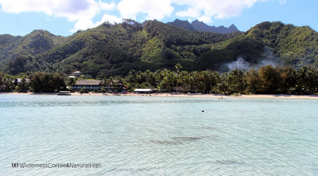
The Cook Islands are the stuff of Pacific dreams. White, sandy, coconut-strewn palm beaches, translucent lagoons in all shades of shimmering blue, and a laid-back atmosphere where everything just circulates on island time.
Craggy peaks and tropical lagoons
But there are also craggy peaks beckoning in the interior of Rarotonga, the main island. The most distinctive one is ‘The Needle’ sticking out in the middle, Te Rua Manga. You can explore it on a walking track across the island, the Rarotonga Cross-Island Track.

Blissful beaches on the island of Rarotonga.

Avarua, the main town on Rarotonga.
Lost in the jungle of Rarotonga
The Rarotonga Cross-Island Track is quite an adventurous route. I almost got lost in the thick jungle, where I had to cross a bewildering amount of streams. At some points, the track was barely recognizable.
Luckily I had borrowed a local booklet that described the route with pictures of significant trees and rocks along the intertwining tracks. This turned out to be very helpful to find the right track again. Eventually I emerged out of the bush on the other end…

Streams flowing from the jungle onto the beach.
The Rarotonga Cross-Island Track
The Cross-Island Track starts just outside Avarua, the main town on the north side of Rarotonga. It meanders through river valleys between the mountain ranges in the centre of the island. The first and last section are on paved roads, but the track itself is a 3,2 kilometres crawl through the jungle. From Ara Tapu, the Circle-Island Road, follow the Avatiu Road inland until you reach the hiking track. The Cross-Island Track finishes at the Wigmore Waterfall, near the village of Vaimaanga Tapere on the south coast.
The total length of the route from Avarua to the main road on the south coast is 7 kilometres. It takes about 4 to 5 hours to hike across the island (if you don’t get lost…) and it’s strongly recommended to do this hike from north to south only.
Subtle orange triangles
On the southern part it’s a lot trickier to follow the Cross-Island Track. The path is much more overgrown and the elusive orange markers are less obvious to spot. But it’s also nicer to finish at the blissful waterfall and natural pool for a refreshing swim at the end of the hike! 😉

The Rarotonga Cross-Island Track. Follow the orange triangles – although they sometimes seem to disappear…

Mountain peaks in the interior of Rarotonga.
Cook Islands bus
From the main road you can hop on the local Clockwise or Anti-Clockwise bus back to Avarua, or anywhere else on the Circle-Island Road. The two island buses depart from Avarua and drive – as their name suggests – either clockwise or anti-clockwise around the island. Both buses do their round trip every hour from Monday to Saturday. There are no buses driving on Sundays.

The Anti-Clockwise bus at Cook’s Corner in Avarua.
Rarotonga Cross-Island hike summary
Distance: 7 kilometres one-way.
Time: About 4 to 5 hours.
Start: Avatiu Road on the north side (Avarua).
Finish: Pâpua Road on the south side (Vaimaanga Tapere).
Highest point: Te Rua Manga at 413 metres above sea level.
Difficulty: Challenging. Thick jungle with multipe stream crossings and scrambling across tree roots.
You can find more information about the Cross-Island Track (and the necessary preparations) on the Cook Islands Tourism website.

A bewildering amount of streams and rivers.

Palm tree shadows on the lagoon beach.
How to get to the Cook Islands
The Cook Islands are in the middle of the South Pacific Ocean between New Zealand and Tahiti. The flight from Auckland only takes 3 hours. But you will actually go back a day in time, as you fly over the international date line between New Zealand and the Cook Islands. This creates the funny experience to arrive on the previous date, and have the same day twice! 😉
Air New Zealand has regular flights to Rarotonga on their trans-Pacific route between Auckland and Los Angeles.
Cook Islands stopover
A stopover in Rarotonga can be arranged on a return ticket to New Zealand, or on a round-the-world ticket combination with other airlines. There are also connections from Australia and Tahiti. On the Cook Islands Airports website you can find an overview of airlines that are currently flying to Rarotonga.

The distinctive Te Rua Manga peak, in the jungle interior of Rarotonga.
Rarotonga (Cook Islands) map
This handy interactive map shows the locations in the pictures above, as well as the Cross-Island Track. You can also zoom in for more details of Rarotonga itself.
Remote Islands – Rarotonga, Cook Islands
This article was originally published as a NaturePic Challenge: A series with pictures of epic nature and places that trigger a natural high.
@ If you have any questions, let me know in the comment section below. I’d love to hear from you! Your questions, comments and suggestions are also helpful for other readers and travellers. Thank you for sharing.
Follow Wilderness Coffee & Natural High on Facebook and Instagram for more stories.

View from Te Rua Manga peak, at the highest point of the Cross-Island Track.
More to explore & discover
Hinchinbrook Island – Unspoiled tropical wilderness
Haleakala – The House of the Rising Sun
Tongariro – The track across Middle Earth
The zen of Stafsnes – The hidden beach
The opal fields of Lightning Ridge – The mesmerizing draw of luminous stone
© All photos and content on this website are my own, and subject to copyright (unless credited otherwise). Please contact me if you want to use a photo or quote a text from one of my articles. You’re welcome to share a link to my blog articles and photos on social media, with a tag and mention to Wilderness Coffee & Natural High.
This article was first published on 9 February 2017.